Thursday, 31 May 2012

May Summary

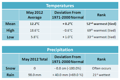
May stats. Click to enlarge.
     In terms of temperatures, May was actually very normal with several ups and downs. However, the average mean temperature was still +0.2°C above normal. Technically, a deviation of just 0.2 would be considered near normal rather than above normal. However, it is safe to say that this is the 11th straight month without below normal temperatures. Not very many Winnipeggers are complaining about this trend of above normal temperatures, however one begins to wonder just how long this can last?


     Rainfall and thunderstorms were the main stories of the month. As there were many convective events, rainfall amounts in the city varied greatly from place to place. Higher amounts fell in northern and western parts of the city with as much as 125 mm. The lowest amounts fell in southern and eastern areas, with as little as 85 mm. Those parts of the city missed out on some big rains on May 18th and 28th, which both dumped 20 to 30 mm of rainfall over western and northern parts of the city.

     There was an abnormally high number of thunderstorm events in southern Manitoba this month. The most memorable thunderstorm events in the Winnipeg area were on the 14th, 18th, 23rd and 27th.

The Thunderstorms:

     Storms on the 14th, along with a cold front, produced severe winds throughout southern Manitoba. These winds along with dry soil conditions created a dust storm over southern Manitoba. Dust storms are generally rare in southern Manitoba, however they do occur from time to time. This particular dust storm was different though. Fierce wind gusts as high as 90 to 100 km/h, along with flying dust and debris created near zero visibility in some areas outside of Winnipeg, making it the worst dust storm in recent memory.
     More storms brought a deluge to western and northern parts of the city on the 18th, dumping as much as 30 mm of rain in some areas. Southern parts of the city missed out on most of the rain, only seeing about 5 mm. The storm flooded some streets, produced frequent lightning, and even brought accumulating hail. A more in depth summary with pictures of May 18 here.

     Yet more storms rumbled through the city near midnight May 23. This particular storm will be known for its magnificient display of lightning. Lightning was flashing almost constantly at times, and there were many cloud-to-ground strokes.
     May 27 featured once again thunderstorms in the city in the evening. These ones once again drenched the city with over 20 mm of rainfall in a couple hours.

     Overall, a very active May...

Warm

     It's shaping up to be a fabulous Thursday in Manitoba, with highs in the low to mid twenties and abundant sunshine.

     Tomorrow, things get a little more turbulent with a north to south surface trough, which may kick off widely scattered thunderstorms throughout southern and central Manitoba. These storms look to remain non-severe, although some storms may produce some hail and gusty winds. It will still be warm however with highs in the low twenties.

     Saturday, things become a little more settled, however a chance for showers still exists in western and eastern Manitoba. We will stay dry here in Winnipeg. Things will really begin to heat up Saturday however. Highs in the mid twenties are expected Saturday, with highs in the high twenties by next week. We may even get a few chances at 30°C in the middle of next week, however that is a little too far to draw to conclusions.

     After Friday, our next chance for showers and storms will be Sunday. I will provide more details on Sunday's potential in the comment section below later today or tomorrow.

** Note: I will not be in the city this weekend and will not have acccess to internet. As a result, the Winnipeg forecast and the thunder forecasts will not be updated from Friday evening to Sunday afternoon. I am sorry for an inconvenience this may cause.

Monday, 28 May 2012

Rain, Rain and More Rain!

    After a wet weekend, mother nature is not quite done with the rain just yet. About 20 to 35 mm of rain fell over Winnipeg yesterday, most of which fell with evening thunderstorms. More rain is on the way later today.
     Periods of rain is set to begin in the Winnipeg area within the next couple hours late this afternoon and early evening. This rain is expected to continue through much of tonight, and be heavy at times. Position of this rain band will determine exactly where the heaviest accumulations fall. At this point it appears the heaviest rain will fall along and slightly north of the Trans-Canada Highway, though uncertainty still exists. I will be updating the comment section below over the next several hours as the exact position of the rain band becomes more certain. Heaviest hit areas could see up to 20 mm of rain by sunrise tomorrow morning.

     A few thunderstorms will be possible as well.

     Luckily this rain is not causing any flooding problems here in Manitoba like it is in the Thunder Bay region. The city of Thunder Bay has issued a state of emergency today following a deluge of rain Sunday night. Up to 100 mm of rain fell locally throughout the weekend. This is on top of another rain storm just last week. Some roads have been washed out, and several buildings have been flooded out, including flooded basements.
Picture credit: CBC Thunder Bay. Full story here
     Looking for a change? Tired of this gloomy weather? Well there is a light at the end of the tunnel! After a cloudy-ish Tuesday, skies will clear Wednesday, with rising temperatures. By Thursday and Friday, highs look to return into the low twenties!

Saturday, 26 May 2012

Gloomy Cold

     After some snowfall over higher elevations of western Manitoba yesterday, today will be a little better in comparison. Winnipeg only reached a high of 9°C yesterday, which was at least 10° below normal.

     Snow this late in the spring in southern Manitoba is not unheard of, especially over the higher elevations of western Manitoba which will see late season snow like this every once and a while. Snows this late in the season are much more rare in the RRV, where they are only experienced a handful of times in a lifetime. Winnipeg's latest snowstorms were in 1882 (15.2 cm on May 20) and 1910 (4.8 cm on May 28). The greatest accumulation we have ever had in June in Winnipeg was a measly 0.5 cm on June 8, 1877.
Pic sent to The Weather Network. Shot in Rossburn, MB by Morgan Sanders
     Today wont be that bad a day around Winnipeg, the Interlake and eastern Manitoba, at least to start ;) There will be lots of sunshine this morning and to start the afternoon, before things cloud up again with a chance of showers this evening. A much steadier rain will begin to push early Sunday, giving southern Manitoba some much needed heavy rain Sunday morning. A few thunderstorms will be possible embedded in the rain. Showers are expected to continue for much of the day as well, so it will be a gloomy end to the weekend. Generally, amounts look to be around 15 to 25 mm, though amounts could reach as high as 30 mm in harder hit areas, and in areas that get thunderstorms.

     Temperatures will be cool both Saturday and Sunday with highs in the low to mid teens in general. Sunday will also be very windy, with gusts up to 70 km/h possible over much of southern Manitoba.

     Monday, wrap-around showers are expected to continue in many areas. A few rumbles of thunder will possible again in southeastern Manitoba with a bit of instability and lift in the afternoon. An additional 2 to 5 mm will be possible Monday, although amounts will vary.

     Looking for warmer weather? Our next warm up looks to begin mid week, so we still have a few more days of this cool weather.

Tuesday, 22 May 2012

Another Round of Storms Tonight

     Thunderstorms are looking likely in southern Manitoba this evening and overnight. An area of low pressure is expected to move in overnight, and it, along with the associated fronts are expected to spark off many storms later this afternoon and especially in the evening. One area is near the warm front, and the second is near the cold front. Here's the current analysis early this afternoon:
Early afternoon analysis with fronts, SBCAPE (yellow) and llj (green arrows)
     The llj, moisture and instability will stream north ahead of the warm front this evening. Most of the storms are expected to form first in North Dakota and southeast Sask/southwest Manitoba later this afternoon, then move east. Some of these storms are expected to be severe. SPC in the US for instance has issued a 5% risk for tornadic activity near the International border, along with a 30% risk of damaging winds and large hail. Personally, I believe that that risk, especially the tornado risk, is a little hyped up for our side of the border; I believe the best risk is in North Dakota. However, large hail and damaging winds is certainly a possibility on our side of the border along and south of the Trans-Canada. The best risk for severe storms on our side of the border will be this evening.

     Storms will be more elevated in southern Manitoba later in the evening and overnight, eliminating the threat of tornadoes. Large hail and damaging winds will remain a threat through the night.

     Here is my thunderstorm forecast map below, valid for the whole night from this afternoon to tomorrow morning. The left is the non-severe storm risk, and the right is the severe risk.
Non-severe risk (left) - light blue = small   dark blue = moderate    green = high...   Severe risk (right) - yellow = slight
     Stay tuned to the comment section below this post for updates.

Saturday, 19 May 2012

Severe Storms Rumble in Southeastern MB

Pic by Rebecca Schleicher
     It was a stormy end to a warm and humid Friday for many of us in and east of the RRV. Storms began to develop after 7 pm, and moved into Winnipeg just before 8 pm. Multiple cells grouped together and battered Winnipeg between 8 and 9 PM. West, central and north parts of the city were hardest hit, where long-lived torrential downpours overwhelmed sewers, flooding some roads. Hail also fell in those areas, with reports of hail as large as marbles. The hail was even accumulating in some spots since it was falling for such a long period of time. There were several reports of 25 to 35 mm of rain with this storm.

     South and east ends of the city evaded most of the storms and as a result only received a general 5 to 10 mm.

     Strange cloud formations were also seen, as some described the storm as looking like a 'giant flying saucer'. Lightning was frequent and at times intense. It was mostly cloud-to-cloud lightning, though there were several cloud-to-ground and cloud-to-air strikes as well.

     The storm is being blamed for a partial roof-collapse. Full story here.

     The storms continued to move east of the city into eastern Manitoba late in the evening with many severe thunderstorm warnings.
Pic by Charmaine Straker
Visible satellite imagery of the storms over Winnipeg near 8:30 PM

Wednesday, 16 May 2012

Incoming Gulf Flow

 After being under the influence of a dry Pacific flow of air for a while, southern Manitoba is now going to be influenced by a gulf flow for the next couple days.

Gulf flow: This flow develops with the presence of a trough over western North America. A strong southerly flow from the Gulf of Mexico develops ahead of this trough, bringing in hot and humid conditions all the way north into Canada. This type of flow usually brings Manitoba its most humid days of the summer, and will often develop only a handful of times a year. (Fact: It was thanks to a gulf flow that Carman, Manitoba, broke the all-time Canadian humidex record of 53 on July 25, 2007). This type of flow is also notorious to bringing southern Manitoba some of its most severe thunderstorms of the year as the trough moves east, clashing with this hot humid airmass.

      This is the type of airmass that will be affecting Manitoba Thursday through to Saturday. As this southerly flow develops, moisture will gradually increase tonight and Thursday, before peaking Friday. It will be a very mild night tonight thanks to breezy southeast winds, with lows only in the low teens. Highs tomorrow will be in the high twenties in most areas, with a few 30°C readings possible, especially in southwestern Manitoba. It will generally be mainly sunny in the morning, and early afternoon, before clouds begin to increase in the afternoon.

     The first chance of thunderstorms will be Thursday late in the afternoon and in the evening. This will be thanks to a low pressure moving into southwestern Manitoba, with building instability/moisture and lift into the area with the gulf flow. These storms will likely be isolated, although with the high instability and lift, any that develop could be strong.

     Friday is looking to be a scorcher. Uncertainty still exists in how far north the warm front will go, although it appears as though this is when the heat and moisture will be at its maximum. Skies will be mainly sunny to start, although cloud will begin to increase in the afternoon, similar to Thursday. Hottest areas look to be in the southeast. Generally, highs between 30 and 32°C look likely along and south of the Trans-Canada. This along with dewpoints in the mid teens will give humidex values into the mid thirties. Things would be much cooler west of the cold front, with highs only in the teens. Stay tuned for updates on the heat, as uncertainty exists.

     With the cold front, some strong thunderstorms will be possible in the afternoon and evening. I will provide updates on this risk in the comment section of this post, and in the thunder forecast tab at the top of the page. On top of those storms, more elevated storms and rains are possible Friday night and Saturday before things finally calm Sunday.

Sunday, 13 May 2012

Nice!

     Summer seems to have made an early appearance this year. We have entered into a long stretch of 20°C + weather, which is expected to last the whole week.
     We are expecting highs in the mid to high twenties in southern Manitoba today and tomorrow. It will be breezy, with westerly winds of 30 to 50 km/h. However, a brief push of colder air is expected to move south Monday night and Tuesday. As this approaches Monday, a few showers or isolated thunderstorms will be possible Monday evening, generally south of the Trans-Canada and Yellowhead highways. Isolated is the key word here. Behind this, highs are expected to remain near 20°C in Winnipeg Tuesday; a little warmer south of the Trans-Canada, while a little colder north of the highway.

     Things warm back up Wednesday with the return of a more southerly flow. Highs in the mid to high twenties are expected Wednesday through to at least Saturday. We will also have a shot at the 30° mark Thursday, Friday and Saturday. Current indications are that there will be a change in the pattern beginning Sunday, although it is a little early to say. This change would bring with it a chance for thunderstorms.

     Enjoy it while it lasts!

     I want to remind everyone though, to be careful with these very dry conditions, especially in southeastern Manitoba. Yesterday, a couple grass fires did sprung up near Sprague. The cause is unknown. It is recommended that you don't throw your cigarette buts out on the ground, and to be aware of the dryness when having a bonfire for the next week. Not only will it be warm and dry this week, there will also be many breezy days, which would help flames to spread quickly.

     Minnesota had issued a red flag warning yesterday, and still has it today. Those red flag warning conditions are being felt here as well.

Thursday, 10 May 2012

Thunderstorm risk over the next 12 hours

      It is not looking likely we'll see much in the way of storms late this afternoon and early evening with the cold front. Moisture is just too low, with surface dewpoints only from 5 to 10°C so far this afternoon, and are not expected to rise much higher. Generally, when it comes to predicting more severe and widespread storm activity, we look for dewpoints in the mid teens or higher. A few storms are not out of the question, although they will likely be isolated and non-severe. The main risk with the storms in this setup is gusty winds due to evaporative cooling

  • Evaporative cooling: « When precipitation in a downdraft evaporates while falling into the drier air below the cloud. The evaporation causes this parcel of air to be colder than the surrounding air. This makes the air more dense which subsequently strengthens the downdraft. This can cause sudden, stronger gusts of wind at the surface. » (Source)
Graphic representation of a dry downburst caused by evaporative cooling


     The best chance of rain and storms for Winnipeg is mid/late evening behind the cold front. A line of rain and/or embedded thunderstorms is expected to form behind the cold front, thanks to forcing from the jetstream. A good 5 to 15 mm will be possible in and around the RRV. The risk of storms significantly decreases past midnight though, due to reduced instability. Personally, I wouldn't expect any thunderstorms in the city in my opinion. I will provide updates in the comment section of this post when they become available. As well, as always, please check the thunder forecast tab at the top of the page when it has been updated for the latest forecasts.

Wednesday, 9 May 2012

3rd warmest & 2nd driest winter nationally

      Environment Canada has put out the country's 2011/2012 winter stats. Full report can be seen here. Here are the highlights of their report:

*Nationwide records began in 1948.

Temperatures

  • National average temperature was 3.6°C above normal (1961-1990 average); the third warmest winter on record. The warmest winter was 2009/2010 at 4.1°C above normal.
  • Winter temperatures have been at or above normal since 1997. Winter temperatures have warmed 3.2°C in the past 65 years.
  •  Prairie temperatures were 6.3°C above normal; the second warmest winter on record. (Consult map to see where exactly Environment Canada considers to be the Prairie zone (yellow)).
Temperature departure from normal - Winter (Dec-Jan-Feb) 2011/2012


Precipitation

  • National precipitation was 18% below normal; the second driest winter on record. The driest winter was 1956/1957 at 20% below normal.
  • The only areas in Canada that had above normal precipitation this winter were northern Manitoba up through to eastern Nunavut, and a small area along the BC coast.
  • Prairie precipitation 56% below normal; the driest winter on record. (Consult map to see where exactly Environment Canada considers to be the Prairie zone (yellow)).

Precipitation departure from normal - Winter (Dec-Jan/Feb) 2011/2012


Full report here