10 - Dec 5-7 Cold Snap; Earliest -30°C Since 1985
A short-lived but severe cold spell swept southern Manitoba from December 5 to 7. In the current climate, it was unusual to have such severe cold that early in the season. In Winnipeg, it dipped below -30°C in the evening of December 6, the earliest in the season we have dipped to -30.0°C since 1985. Note that it was only tied 29th earliest first -30°C of the season since 1872. This is because the climate was much colder in the 19th century, with temperatures below -30°C common as early as late November. The low on December 6 was -31.4°C and on December 7 it was -33.4°C. These were only one degree shy of the record lows for each date, which were set 140 years ago. It was also only the 15th year since 1872 to reach -33.4°C or colder this early in the season. In fact, 1964 and 1985 were the only other years in the past 115 years. Most of the suburbs did dip below -30°C as well, but The Forks only dipped to -27.8°C thanks to the urban heat island effect.
The coldest temperatures were in the Parklands area of western Manitoba where widespread lows below -36°C and isolated lows near -40°C were recorded. Some lows down to -37°C were recorded not far from Winnipeg as well.

9 - Father's Day Heat Wave Shuts Down Manitoba Marathon
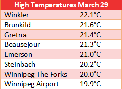
2022 did not have nearly as many days above 30°C as 2021. Only 7 days managed to reach 30°C, below the normal of 13 days and a far cry from the record 35 days we saw in 2021. Despite this fact, the hottest day of the year on June 19 was still impressive. It was a brief but intense hot spell, with a high of 37.0°C. This not only broke the daily record of 33.3°C in 1888, but was also the 5th hottest June day since 1872. A summary of high temperatures in southern Manitoba is listed below. Portage Mb Ag recorded the highest temperatures of 38.6°C. High temperatures ranged from 32-35°C in southwestern Manitoba to 35-38°C in the Red River Valley and southeastern Manitoba.

High humidity accompanied the heat, with record dewpoint values reaching 22°C in Winnipeg. This produced a maximum humidex value of 45.1, only the second occurrence of humidex over 45 in June since 1953 and the earliest in the season. High humidity resulted in very warm nighttime temperatures as well. The daily minimum of 22.0°C broke the daily record of 21.1°C in 1888. Temperatures were still 30.7°C at 1am, before a front dropped us back to 21°C by early morning. The Airport managed to rack up 61 consecutive hours with temperature above 20°C. There were also 12 consecutive hours of humidex above rounded 40, the 4th longest since 1953.
Elsewhere in Manitoba, daily minimum temperatures as high as 23.3°C and 23.2°C were recorded in Cypress River and Morden using ECCC stations. At Manitoba Agriculture stations, daily minimums as high as 24.5°C, 24.1°C and 23.6°C were recorded in Treherne, Windygates and Holland respectively. All these higher minimum temperatures were at least partially the result of slight downslope winds off the escarpment and Turtle Mountains.
The heat was not without impact. The Manitoba Marathon in Winnipeg was cancelled after it had already started, due to rising heat and humidity in the morning. The day also brought severe thunderstorms to western Manitoba and the northern Interlake in the late afternoon and evening. Wind gusts up to 100 km/h and localized downpours over 50 mm were recorded, mostly by Manitoba Agriculture's stations. Some trees were uprooted, grains bins knocked over, houses and cars damaged, and hydro poles knocked down. More than 4,000 people lost power, some of which had to wait until the following day to be restored. Heavy downpours also caused localized flooding. Hail up to baseball sized was also reported around Benito and Roblin.
 |
| Photo by Natasha K. in Gypsumville MB |
8 - October 23-24 Colorado Low Provides Late Thunderstorms
The first major Colorado Low of the season struck southern Manitoba October 23 and 24. It brought primarily heavy rain and thunderstorms, an unusual occurrence that late in the season (but not unprecedented). Waves of thunderstorms moved through during the late evening and overnight hours. At Winnipeg Airport, the thunderstorms on October 24 were the 9th latest in the season since 1953 and the latest since 2007. Thunderstorms have occurred later in other parts of the city however. I have listed below some of the latest events that I have been able to dig up (likely are other events I am not aware of yet):

At least partly responsible for the unusually late and widespread thunderstorm event was the amount of moisture and instability the system had to work with. Southeastern Manitoba briefly got a feel for this humidity the morning of Oct 24 as the warm sector of the system quickly moved through. Dewpoints as high as 16°C were recorded south and east of Winnipeg. Winnipeg Airport recorded a dewpoint of 14.0°C, which was actually just shy of the daily record of 15.6°C in 1963.
 |
| Downtown Winnipeg lightning Oct 24, by Jess M. on Facebook |
Generally, 10 to 30 mm of rain fell across southern Manitoba. The heaviest amounts, in the 25 to 40 mm range, fell from around Killarney to the Red River Valley and to the southern shores of Lake Winnipeg. This included Winnipeg, with Winnipeg Airport recording 33.5 mm of rain. This broke the daily record of 17.8 mm in 1956, and was about an entire month's worth (normal October is 31 mm).
The storm system brought a heavy snow storm in Saskatchewan. The Moose Jaw area was hardest hit with 30 to 40 cm of snow. The snow was very wet and came down fast with near zero visibility, weighing down on trees and power lines. The event was somewhat similar to the October 2019 ''treemaggedon'' in Winnipeg. Fallen trees at times blocked roads in Moose Jaw with this storm, and highways were trecherous and eventually closed. Over 12,000 customers were without power. Regina received about 5 to 10 cm with the storm. Parts of southeastern Saskatchewan had an ice storm with the system. Parts of the Parklands in Manitoba also received freezing rain.
 |
| Fallen trees and branches in Moose Jaw, photo by Lia N. on Twitter |
7 - Humid Summer with Highest Dewpoint on Record
Thanks to wet conditions in 2022, it was a very humid summer. The average dewpoint of 13.6°C at Winnipeg Airport from June to August was tied 6th highest since 1953 and the highest since 2016. 20 days saw dewpoint rise above 20°C, the most since 2015 and tied with 1955 for 5th most since 1953.
The highlight of the summer humidity was on July 17 when oppressive dewpoints in the high twenties occurred. At Winnipeg Airport, the dewpoint temperature reached 27.4°C, the highest on record since 1953. This beat the previous record of 26.1°C in 1966. This pushed humidex values up to 45.6, the second time that humidex values reached 45 over the summer. In fact, it was the only summer on record since 1953 to have humidex over 45 more than once. Only 7 other dates since 1953 managed to reach a humidex of 45.
Elsewhere in Manitoba, dewpoint temperatures reached as high as 28.7°C in Great Falls and 28.0°C in Carman. In Great Falls, this produced a humidex of 48. Portage la Prairie had humidex of 47.
 |
| Sunset this summer |
6 - June 24 Thunderstorm Dumps 50 mm in 30 Minutes at the Airport
One of the heaviest thunderstorms of the year drenched Winnipeg on June 24. It just so happened that the Airport was one of the hardest hit with the storm, providing a detailed look at the evolution of the storm and its rain amounts as the station recorded minutely precipitation. I have displayed the evolution of rainfall amounts at the Airport in the following graph. The graph shows 1-minute rainfall amounts in yellow bars, with 5-minute, 10-minute, 30-minute and cumulative accumulation in red, green, grey and blue lines. The graph covers the time period from about 6:12 pm to 7:06 pm, so just under an hour.
 |
| Rainfall intensity graph for Winnipeg Airport June 24 during a 1-hour period (1-min, 5-min, 10-min, 30-min and cumulative rainfall) |
As the graph shows, rainfall amounts were impressive for such a short period of time. 50.0 mm of rain fell in 30 minutes, a new record for the Airport with such records going back to 1953. For any given location in Winnipeg, this represents about a 1 in 100 year event. The previous record was 43.7 mm in 30 minutes in July 1996. In addition to this record, other intensity records were also broken:
In an hour timeframe, 53.3 mm of rain fell, only the third occurrence of 50+ mm in an hour at the Airport since 1953, as well as the third highest. The daily amount was 55.7 mm, not only a new daily record (old record 40.6 mm in 1877) but also the 6th rainiest June day since 1872.
Of course, not only the Airport was hit by the storm. Torrential rainfall amounts also fell in northern, eastern and southeastern portions of the city. Generally, 40 to 60 mm fell in these areas. The storm produced a strong gradient in rainfall amounts across the city, with only around 5 mm in other areas. In areas hit by the storm, severe street flooding occurred, making travel difficult. Elsewhere in the Red River Valley, rainfall amounts were very variable. The heaviest amounts fell around Dominion City and Rosa with 50 to 100 mm recorded. Quarter sized hail was also reported in southeast Winnipeg.
 |
| Pandora Ave flooded, photo by Kris P. on Twitter |
5 - Wettest Summer Since the 2000s with Multiple Drenching Thunderstorms
Wet weather in the spring continued into the summer in the form of multiple heavy thunderstorms. June, July and August all recorded over 100 mm at least somewhere in the city. The Airport recorded 316.9 mm of rain during the three month period, the 13th rainiest summer on record since 1873 and the rainiest since 2005. The Forks received even more rain: 360.2 mm. This would be equivalent to a 6th rainiest summer and rainiest since 2000 using the Airport's records.
 |
| Precipitation rankings May to October 2022, via Manitoba Hydrologic Centre |
Some of the heaviest thunderstorm events in Winnipeg included June 24, July 19, August 15 and August 18. The June 24 event was already summarized in the #6 event of this year. Other events in southern Manitoba also dropped significant rainfall such as June 13-14.
June 13-14 heavy thunderstorms in southwestern Manitoba
Locally heavy thunderstorms dumped 50 to 100+ mm of rain in parts of southwestern Manitoba on June 13 and 14. The RM of North Norfolk (MacGregor, Austin areas) and Souris were hardest hit. The RM of North Norfolk declared a state of emergency due to overland flooding which washed out roads and culverts and covered fields. Souris recorded 95 mm, Forrest 80 mm, Rivers 80 mm, and Austin 104 mm (Manitoba Agriculture stations). 51 mm fell in one hour in Souris. Brandon Airport recorded 57 mm. Amounts were lower in southeastern Manitoba with a general 10 to 35 mm. Note that there were also storms on June 12 which dumped lower amounts, but still in the 10 to 50 mm range. The 3-day total for Austin was 122 mm and Souris 106 mm.
 |
| Backside of storms in Winnipeg June 14, photo by David M on Twitter |
July 19 heavy thunderstorms flood Teulon, cottage country and southeastern Manitoba with 100+ mm
Two waves of heavy thunderstorms moved through southern Manitoba on July 19. The first complex of storms moved across southern Manitoba early in the morning, and the second complex developed in the afternoon in southeastern Manitoba. In Winnipeg, a general 25 to 50 mm of rain fell. This was actually small in comparison to areas around the city. The province issued another overland flood warning ahead of the event and for good reason. An unusually widespread area southeast and northeast of the city saw amounts over 100 mm. Some amounts were truly remarkable, with 140 mm recorded east of Libau. One Weather Underground station northeast of Teulon also recorded 173 mm, but I am not sure of the accuracy. The table below lists the highest amounts recorded.

Teulon was one of the hardest hit areas from the storms. With over 110 mm of rain, the town suffered severe flash flooding, with basement, streets, yards and fields under water. About 800 homes in the town were damaged by flooding. This represented about 75% of homes in the town. At the height of the storm, the town received over 40 mm of rain in an hour, two hours in a row. The Whiteshell was also hard hit with over 100 mm, 70 mm of which fell in only an hour. This led to road washouts and some highway closures. Even the Trans Canada Highway east of Kenora was closed due to a washout. The Marchand area of southeastern Manitoba was also floooded by over 100 mm, with water surrounding homes and businesses and with some highways washed out. A state of emergency was issued and it would take a week or two for floodwaters to move out.
 |
| West Hawk Lake flooding; from Steinbach Online via WhiteshellCottagers Facebook |
 |
| Marchand flooding, via Steinbach Online |
Damaging winds acompanied the storms in the early morning hours. The strongest wind gusts were in southwestern Manitoba. Gusts between 100 and 126 km/h were recorded around Ninette, Clearwater, Baldur and Holland. Environment Canada even had tornado warnings right through to 5am as a severe thunderstorm moved eastward to St Malo. Wind damage was recorded around St Malo, with branches down, but no confirmations of a tornado were received. Around 15,000 customers were without power as a result of the storms in southern Manitoba. Of meteorological interest, the complex also produced wake-low winds around Portage and Elie, to near 90 km/h, in the morning.
August 15 'MCV'-induced heavy thunderstorms
A dissipating complex of thunderstorms from Saskatchewan caused a leftover circulation or two to move through southern Manitoba on August 15. This circulation, called an ''MCV'' or ''mesoscale covective vortex'', is known for generating new daytime severe thunderstorms. This was exactly what happened in the afternoon in south-central Manitoba. This new slow-moving complex of thunderstorms formed around Portage la Prairie and moved eastward into the Winnipeg area and southeastern Manitoba, producing yet another deluge of rain. A swath of over 50 mm of rain fell from Portage to Winnipeg to Beausejour. Localized amounts over 50 mm also occurred in parts of the southern Interlake and southeastern Manitoba. The following table summarizes the highest amounts:

As you can see, Winnipeg was actually one of the hardest hit areas. 90.1 mm of rain fell at The Forks. In general, 40 to 90 mm fell through the whole city. Once again, streets and basements flooded in the city. Some locations received over 50 mm in an hour. A house was also struck by lightning and a few power outages were reported south of the city. The initial storms south of Portage also dumped hail up to golf ball sized around Rathwell.
 |
| Radar imagery showing the complex of storms moving into Winnipeg |
August 18 another deluge overnight
A disorganised area of thunderstorms moved through the Red River Valley and southeastern Manitoba during the overnight and early morning hours of August 18. A line of storms organised just before hitting Winnipeg, and moved slowly through the city, producing another deluge in the city. The southeastern portion of Winnipeg was hardest hit with locally up to around 80 mm of rain. 50 to 60 mm of this rain fell in only an hour. Elsewhere in the city, amounts ranged from 10 to 15 mm in the north, to 40 to 60 mm in western and southern parts of the city. Once again, basements and streets flooded as a result of the heavy downpours. Nickel sized hail was also reported in Old St Vital, and lightning was bright and nearly constantly flashing. A summary of the highest rainfall amounts is listed below:

Later in the afternoon of the same day, a weak light of showers and thundershowers produced a funnel cloud near Niverville.
4 - Long and Harsh Winter with Deep Snow and Blowing Snow
It was a winter to remember, with incredible amounts of snow and persistently cold temperatures. Starting about a week before Christmas, snowstorms visited us every few days until late February when things started to temporarily calm down. The majority of these systems were clippers. Each would drop 2 to 10 cm, which adds up with time. 131.0 cm fell from December to February, the 3rd snowiest meteorological winter since 1872, and the snowiest in 106 years. This was almost double the normal of 69 cm. February was most impressive, recording 50 cm, the snowiest since 1921 and more than triple the normal of 15 cm.
Of course, in this part of the world, the winter we feel is actually longer than the three months of December to February. November and April were also snowier than normal, particularly April which featured several snowstorms and was the 4th snowiest on record. In total, from October to April, there was 215.0 cm of snow, the 2nd snowiest October to April period on record since 1872.

The incredible amount of snow made it difficult for the city to keep up with snow clearing. Ruts were terrible due to cold conditions which prevented the city from clearing roads down to the pavement. Snow piles were massive, making it hard to see around them. These large piles combined with ruts caused the cancellation of some school crossing guard programs at times due to safety issues. MPI reported more accidents than usual this winter. The 2022 snow clearing budget for the City of Winnipeg was wiped out and, in fact, had overruns exceeding 15 million dollars. On the bright side, snowmobilers and cross-country skiers were happy. Some businesses in recreational spots benefitted from the increase in activity that resulted.
 | |
|
Although it was not an overly impressive winter for cold historically, it was cold by 21st century standards. The mean temperature of -17.5°C from December to February was three degrees below normal, but only tied 43rd coldest since 1872. It was, however, the coldest winter since 2013-2014. Daily low temperatures were the most impressive, averaging -23.2°C, almost four degrees below normal and the second coldest since the late 1970s.
The most abnormally cold months were February and April. February averaged -19.7°C, almost six degrees below normal and the 24th coldest since 1872. Daily lows averaged -26.0°C, almost seven degrees below normal and the coldest since the late 1970s. April was the 16th coldest since 1872, with a mean temperature of -0.3°C, about four degrees below normal. Due to cloudiness and wet weather, April high temperatures were most impressively cold. Average highs were 3.3°C, almost seven degrees below normal and the 7th coldest on record since 1872.
It was also tied the 6th windiest winter since 1953 with an average sustained wind of 20 km/h. Strong winds combined with hefty amounts of snow produced frequent blowing snow in open areas. 27 days from December to February recorded blowing snow at the Airport, tied with 1972 for 3rd most since 1953. 26 days saw blowing snow in January and February combined, a new record since 1953.
Frequent blowing snow and blizzards posed a challenge for Manitobans as highways were frequently closed. Even the Perimeter was closed at least nine times throughout the winter. Nobody could even remember the Perimeter ever being closed, due to weather, before this winter. South of the border, Grand Forks recorded the most blizzards on record in a winter according to the NWS. Rural areas also had many days with school closures, an impact somewhat mitigated by the pandemic which resulted in students being able to learn virtually more easily.
The amount of snow combined with persistently cold weather and minimal thaws resulted in exceptionally deep snow cover by February and March. Snow depth at the Charleswood site peaked at 60 cm in February and 61 cm in early March, the deepest snow cover since 1997. Although these measurements were representative of backyards, open fields had about half that snow cover - around 35 cm. This is still quite deep compared to normal, and was a major reason that blowing snow was such a problem over the winter.
Some snow drifts lasted in shaded areas through to the first few days of May, a grim reminder of the winter that was. A general melt occurred in the second week of April with most snow disappearing, but subsequent snowstorms resulted in a general disappearance of snow not until the very end of April. The constant freeze-thaw cycle during the wet April resulted in terrible potholes that riddled the city, making travel trecherous and risky. Green up of trees was delayed, as well as the city's spring cleanup. Manitoba does not keep track of green up, but south of the border greenup was around 3 weeks late according to the USA National Phenology Network.
 |
| A lingering snow drift on May 1st |
There were a few notable winter storms through the winter that are summarized in the following subsections.
January 21 near-blizzard
A storm produced 5 consecutive hours of near-blizzard conditions at Winnipeg Airport on January 21. Only around 5 cm of snow fell (10-15 cm also fell just 3 days prior, however), but with wind gusts up to 75 km/h, visibility was reduced to near-zero at times in blowing snow. Both the Trans Canada and Perimeter Highways were closed, but not before some drivers became stranded in the ditch.
 |
| Near-zero visibility on the Perimeter - posted on twitter by @RhiRhiDraws |
February 1 blizzard
One of the worst storms of the winter struck on January 31st and February 1st. Only about 6 to 8 cm of snow fell, but sustained winds up to 60 km/h with gusts up to 80 km/h produced a severe blizzard on February 1st that lasted for hours. In total, blizzard conditions lasted at the Airport for 9 consecutive hours, the longest blizzard since the blizzard of April 1997 and tied 10th longest blizzard since 1953. There were also near-blizzard conditions the evening of the 31st, making for a rather prolonged storm event. Many major highways were closed, including the Perimeter, highway 75, the Trans Canada, highway 12 and highway 59.
 |
| Saskatchewan Avenue, Winnipeg, posted on Westman Storm Chasers Facebook by Shelley L. H. |
Travel was next to impossible as visibility was literally zero in open areas and drifts engulfed highways. The prolongness of the event was dangerous, and unfortunately, more than 100 drivers trying to venture out became stranded on the Perimeter Highway due to drifts as high as cars blocking the highway. RCMP checked on the people to make sure they were staying warm and the city provided a bus for people to stay warm in if needed. People were stranded for almost the entire day. One BC man travelling through the province was stranded in his car for 13 hours on the Trans Canada west of Winnipeg. Even within the city, newer neighbourhoods with not much to stop the blowing snow became trecherous with dozens of people becoming stranded trying to drive out.
 |
| Drivers stranded on the Perimeter Highway, photo by Dustin V. via Steinbach Online |
Just to add to the slippery highway conditions during the blizzard was a period of freezing rain ahead of the storm on January 31st in the afternoon.
The clipper system also struck Saskatchewan with dozens, if not hundreds, of people stranded on highways, many bunking in motels for the night. Pretty much all highways in Saskatchewan were closed as a result of the blizzard.
 |
| Letellier webcam showing whiteout conditions |
February 11 storm
Another storm dropped 5 to 10 cm of snow and produced wind gusts up to 70 km/h on February 11. Major highways were again closed including the Perimeter, the Trans Canada and highway 75. Traffic jams on the Trans Canada were reported as a result of drifts blocking the highway, particularly east of the city. Many people were again stranded as a result.
February 18-20 three-day series of storms
A series of systems brought three days of snow and blowing snow across southern Manitoba. In total, 15 to 20 cm of snow fell in Winnipeg, which combined with wind gusts between 50 and 70 km/h to produce significant blowing snow. Although an official blizzard was not set at the Airport, conditions were still very bad especially considering the prolongness of the event which simply carved up drifts to magnificent heights and covered highways. Most major highways were once again closed, including the Perimeter Highway, highway 75 and the Trans Canada. Multiple collisions were reported.
 |
| Feb 20 highway 2 drifted over, posted on Facebook Highway Conditions Hwy10 South Brandon to US Brdr, by Rhonda J. P. |
March 8, 10-11 and 12 blowing snow events cause Perimeter to close three times in one week
Barely any snow fell with a system on March 8, but wind gusts up to 70 km/h and plenty of snow on the ground to blow caused significant blowing snow. Low visibility and drifts on highways made travel trecherous. This resulted in a collision involving 80 vehicles on a section of McGillivray Blvd just outside the city. Three people were taken to hospital for injuries caused by the collisions. So many people were involved that the Health Sciences Centre issued a code orange alert, which is issued to increase capacity in cases of potential significant increase in patient demand. Many highways were eventually closed during the storm, including the Yellowhead, Trans Canada and Perimeter Highways. Regardless, several people became stranded again.
Then, on March 10-11, a couple centimetres of snow and winds gusting up to 70 km/h caused yet more blowing snow. The Perimeter and Trans Canada Highway closed again.
On March 12, another clipper system dropped a couple centimetres of snow along with wind gusts up to 60-70 km/h. After a few collisions, RCMP did not hesitate to close the Perimeter yet again for the third time in a week.
 |
| March 12 Deacon's Corner, photo via Steinbach Online |
April storms only prolong the winter that would never end
I won't get into much detail about April, as that is dealt with later in this post, but I do want to comment that the Perimeter was closed yet again on April 7 due to blowing snow in gusts up to 70 km/h. With the Colorado Low of April 13-15, the Perimeter was closed for a ninth time. Following this Colorado Low, incredibly cold weather settled over southern Manitoba for several days. Winnipeg suffered five consecutive days that did not even exceed the freezing mark, the longest such streak that late in the season on record since 1872. A record low of -13.7°C occurred on April 17 as well as a record low maximum of -3.8°C on April 25. The cold on April 17 and 18 was impressive across southern Manitoba. Both Carman and Wasagaming dipped below -20°C, the 2nd latest occurrences of -20°C weather in southern Manitoba as far as I know. The latest was April 23, 1967 in Dauphin. Wasagaming dipped to a record -21.9°C on the 18th.

3 and 2 - The Colorado Low Train of April and May & the Spring Flood
An unbelievable string of Colorado Lows struck southern Manitoba from mid April to late May. A Colorado Low would hit about once a week, a streak which rarely occurs in this region. We were hit by at least six Colorado Lows, with a few other major systems in between as well. The string of Colorado Lows, which continually made the news, inspired the song ''Another Colorado Low'' by Colin Lougheed on Twitter. Each dumped significant rain and snow across southern Manitoba, and this combined with a snowy winter and late cold spring produced one of the worst spring floods on record. For the Red River, it was the 6th worst flood in 200 years by water volume (damage is mitigated nowadays by flood control measures such as floodways and dikes). The flood resulted in Highway 75 being closed for over a month. For the Winnipeg River, it was the worst flood on record, aided by the highest water levels in Lake of the Woods since 1950. Some of the larger communities flooded this spring included Minnedosa, Peguis First Nation and Morden. All the flooding resulted in tens of millions of dollars of damages. The province said it would have to repair more than 2,000 roads, bridges and culverts. In total, 45 local authorities, one provincial park, 11 northern communities, and 9 First Nations declared states of local emergency due to flooding throughout the spring.
 |
| May 16 photo of Red River flooding along Hwy 75 by St Adolphe |
The whole weather pattern in general was not dissimilar to the flood of 1826, the worst Red River flood on record: a very snowy winter, a cold delayed spring, and a very wet late April through May period. Some differences that made 1826 much worse were that it was preceded by two wet years and a wet fall in 1825, and April was colder with winter snow not melting until May. Not that this April wasn't cold. Mean temperature in April was four degrees below normal and daily high temperatures averaged almost seven degrees colder than normal. Cold days and warmer nights were the temperature story of April and May due to the excessive cloudiness and wet weather.
The two month period of April and May was easily the wettest on record in Winnipeg since 1873. The old record was 278.4 mm of precipitation in 1896. Parts of the city received over 300 mm this year. The Forks received 305.2 mm, absolutely astonishing given the normal amount is barely 100 mm. At the Airport, 284.4 mm fell. The following table shows 289.2 mm due to using The Forks during some snow and blowing snow events in March and April of which the Airport gauge undercaught some snowfall.

You may have noticed that I have combined the number 3 and 2 spots in the top ten stories of this year due to the amount of information. This is the first time I have done this. The extremeness and impacts of the Colorado Train of 2022 simply could not all fit in one ranking.
 |
| Satellite image showing flooding and high water levels (LaurenDauphin/NASA Earth Observatory via CBC) |
3 - The Colorado Low Train of May - 2nd Wettest May on Record
At least three Colorado Lows were in May. There were other systems throughout the month as well, some of them significant. It was the 2nd wettest and 2nd rainiest May on record at Winnipeg Airport with 166.2 mm, eclipsing the 160.0 mm that fell in 2010. Only 1977 had more with 177.7 mm. 22 days had rain this May, tied with 1969, 1974 and 2001 for most on record.
May 9 Colorado Low
A general 10 to 30 mm of rain fell across all of southern Manitoba with a Colorado Low on May 9, somewhat unimpressive compared to the previous systems of April. However, it was very unwelcomed given saturated soils and yet more rain to come later in the week. The province issued an overland flood watch for all of southern Manitoba, and a flood warning for the Dauphin area. Localized rainfall amounts up to around 40 mm were recorded north of Brandon and southwest of Melita.
May 12-13 Colorado Low
Another Colorado Low brought rains and very strong winds across southern Manitoba May 12 and 13. Overland flood watches were still in place by the province, and had been upgraded to warnings in western and southeastern Manitoba. Already, 28 states of local emergency had been declared across the province due to flooding even before this next system moved in. This time, however, south-central and southeastern Manitoba were spared the worst with just a general 5 to 15 mm. This was good news as water levels along the Red River were cresting or already beginning to fall slowly.
It was a different story in southwestern Manitoba where general rainfall amounts of 15 to 30 mm fell. The heaviest hit area was the Parklands which saw amounts reach in excess of 50 mm in some parts. This, combined with snow melt from previous storms, caused severe flooding along creeks and rivers. Minnedosa was particularly hard hit as the Little Saskatchewan River overflowed its banks inside the town, flooding out some streets. Several volunteers helped build sandbag dikes along the river and town crews removed logs from the dam to relieve pressure on the dam. The flood brought flashbacks of a similar flood in 2020 in the community.
 |
| Flooded streets in Minnedosa, posted on Facebook by the Neepawa Banner & Press |
Further north, some highways were also washed out in and around the Duck Mountains. Pine Creek First Nation on the shores of Lake Winnipegosis was hit hard, with four homes destroyed and around 30 people evacuated. The heaviest rainfall amounts included: 85.9 mm in Ethelbert, 60.8 mm in Drifting River, 59.9 mm in Birch River and 50.6 mm in Minitonas (Mb Ag amounts).
The storm system also brought some of the strongest winds of the season. Southerly wind gusts between 80 and 100 km/h were recorded from Lake Winnipeg southwestward to the Morden and Pilot Mound areas. This was enough to cause some damage, such as to the sign on top of the Richardson Building in Winnipeg. Power outages also occurred to at least 1500 customers, with some power poles knocked over by the wind in rural areas. Strong winds also caused waves and rising water levels in the flooded Red River Valley.
 |
| Poles knocked over by wind along the TCH, posted on Twitter by Kim |
South of the border, the storm brought one of the worst severe thunderstorm outbreaks of the past twenty years. Nebraska, South Dakota, Iowa and southern Minnesota were worst hit with widespread wind gusts over 120 km/h, causing a haboob. According to the NWS, the event featured the second most reports of hurricane force winds on record since 2004. In North Dakota, heavy rains occurred again with around 50 mm in the Grand Forks area and over 75 mm in parts of northwestern North Dakota.
May 17-20 Heavy Rains
A more complex series of systems brought a general 20 to 50 mm of rainfall across southern Manitoba May 17th to 20th. From the Winnipeg area to the Riding Mountains area, a swath of 50 to 70 mm fell. This was bad news for Minnedosa which was still battling floodwaters from the previous storm. 39 municipalities had already declared states of local emergency due to flooding. The Whiteshell area of southeastern Manitoba was one of the next to issue a state of local emergency on May 20 due to flooding worsened by additional rainfall. Water levels in southeastern Manitoba's lakes and rivers were near historic highs.
Behind the system, it was cold enough for snow. The Riding Mountain area started to see snow on May 19, and was enough to accumulate. In Winnipeg, light snow flurries fell on May 21, but did not accumulate. It was actually the first time snow was recorded in the city on May 21st, since 1872. It was also the latest date to see snow since 2007. On May 20, snow was also recorded as far south as western North Dakota.
 |
| Riding Mountain webcam late evening May 19 (Manitoba 511) |
May 30-31 Colorado Low
The final Colorado Low struck May 30 and 31. Similar to the May 12-13 Colorado Low, this one brought another combination of heavy rains and damaging winds. Overland flooding was again a problem with the province issuing another overland flood warning. Southwestern Manitoba was luckily spared the worst of this system in terms of rainfall. Elsewhere, a general 20 to 60 mm fell. The heaviest amounts over 50 mm were particularly concentrated in the Red River Valley and Interlake, with the Morden area receiving the heaviest amounts as high as 80 to 100 mm. In Winnipeg, a general 30 to 60 mm of rain fell over the city. Some underpasses were closed due to flooding, and many streets and basements were flooded. Outside the city, farm fields were once again under water, further delaying seeding for farmers who hadn't had the chance yet. Flooding was exacerbated by heavy downpours in thunderstorms.
 |
| Snapshot from a video near Miami MB posted by Tracy D. on Facebook |
Northwesterly wind gusts between 80 and 100 km/h also occurred behind the system on the 31st. Minnedosa (Mb Ag station) recorded the strongest wind gust of 105 km/h. Several wind gusts over 90 km/h occurred throughout the Red River Valley. The wind was strong enough to rip shingles, knock over trucks on the Trans Canada Highway, and cause power outages. Over 15,000 hydro customers lost power across southern Manitoba as hydro lines were downed by the winds. Some customers had to wait a day for restoration. The winds combined with high lake levels also caused storm surge along the southern shores of Lake Winnipeg. Some cottage areas experienced flooding and one of the seawalls at Gimli was ripped apart by waves. Some residents along Dauphin Lake were also evacuated due to high water levels from high winds. Many campgrounds, beaches and boat launches were closed by the province due to high water levels and winds.
2 - The Colorado Low Train of April - 2nd Wettest April on Record
Three of the Colorado Lows were in April. There were also other systems throughout the month that were less significant. In the end, it was the 2nd wettest (118 mm), 2nd rainiest (96 mm) and 4th snowiest (43 cm) April on record since 1872 at Winnipeg Airport. These were truly remarkable amounts - around four times the normals. The following table lists the top five wettest Aprils pulled from my record books website. Note that the precipitation amount of 123 mm is due to replacing some snow water equivalent with The Forks during the mid April event due to wind-induced undercatch at the Airport.

April 13-15 Major Snowstorm
The first major Colorado Low hit southern Manitoba April 13 to 15. Prior to the event, weather models were forecasting the worst blizzard to hit Winnipeg since 1997. Due to the impacts that would result, Environment Canada used strong language in its warnings to encourage people to prepare accordingly. Seldom do we hear the organisation use the sort of language it did:
WEDNESDAY, WITH WIDESPREAD HIGHWAY CLOSURES A NEAR-CERTAINTY. BY
WEDNESDAY EVENING EVEN TRAVEL WITHIN COMMUNITIES MAY BECOME
IMPOSSIBLE AS THE HEAVY SNOW AND STRONG WINDS CONTINUE... AND MORE
OF THE SAME IS EXPECTED ON THURSDAY.
DO NOT PLAN TO TRAVEL - THIS STORM HAS THE POTENTIAL TO BE THE WORST
BLIZZARD IN DECADES. STOCK UP ON NEEDED SUPPLIES AND MEDICATIONS
NOW. POWER OUTAGES ARE LIKELY, RURAL AREAS IN PARTICULAR SHOULD BE
PREPARED FOR EXTENDED OUTAGES. ''
I mention this because it was an interesting part of the story of this storm system. People did listen to the warnings, and the city became almost like a ghost town during the storm. People stayed home and did not venture out, many organisations closed their doors and all Winnipeg schools were closed for the first time since 1997. The Winnipeg Jets game was also postponed. Most city services including libraries, garbage collection, pools and rec services were temporarily suspended in both Winnipeg and Brandon. Dozens of flights were cancelled at the Brandon and Winnipeg Airports. In addition, prior to the event, store shelves were emptied as people stocked up on food and generators, an occurrence that rarely occurs here prior to a storm. Agencies and governments were also well prepared, including the City of Winnipeg, The Manitoba government, CAA, the RCMP, local charities, hospitals and Manitoba Hydro. Provincial highways were closed proactively as soon as the snow began rather than when conditions were already at their worst. As a result, all highways from the Red River Valley westward were closed. Impacts from the storm were remarkably minimal for a storm of this calibre as a result, with few accidents and few people stranded. And although a few thousand did lose power, it was a far fetch from the storm of October 2019 in terms of power outages.
 |
| City nearly a ghost town April 13 - photo via Winnipeg TMC |
In the end, Winnipeg itself was spared the worst of the storm, with the heaviest snows falling slightly north and west of the city. Regardless, 29 cm still fell on the city, the 4th largest snowstorm in April since 1872 and the largest since 1997. Strong winds carved out drifts at least 60 cm deep. Generally, 30 to 50 cm fell north and west of the city with localized amounts up to 80 cm around terrain features such as the Riding and Turtle Mountains where snow was literally waist deep in spots. In addition to the snowfall, winds gusted between 80 and 90 km/h across southern Manitoba producing whiteout conditions in snow and blowing snow. At Winnipeg Airport, the storm met the criteria for a near-blizzard (visibility 800 m or less for 3 hours or more in winds sustained 30 km/h or higher), the first in April since 1999 and the latest in the season since 1992. Near-blizzard conditions lasted six consecutive hours.

As seen in the satellite imagery below from April 16, the snowstorm also hit North Dakota and southeastern Saskatchewan hard. 30 to 40 cm fell in the Estevan area of Saskatchewan. In North Dakota, Minot received 75 to 90 cm of snow. A general 40 to 75 cm of snow fell from Dickinson in the southwest to the Turtle Mountains. Strong winds carved out drifts 2 metres high or more. Impacts were also muted in the state by ample lead time and strong wording from weather agencies.
 |
| April 16 visible satellite showing snow cover (in green) after the storm, via College of Dupage |
April 22-24 Colorado Low
The next Colorado Low brought more of a mix of precipitation across southern Manitoba. Primarily rain fell in south-central and southeastern Manitoba while heavy snow fell once again in western parts of the province, especially around the Riding and Turtle Mountains. The system also produced numerous thunderstorms in the Red River Valley and southeastern Manitoba with at times torrential downpours and frequent lightning; a bizarre occurrence at temperatures only two degrees above freezing. The storms even dropped some pea sized hail in some areas.
The combination of heavy rains, frozen ground and recently melted snow from the previous storm resulted in some of the worst overland and basement flooding ever seen in the area. With the ground unable to absorb much rainfall, water often pooled along houses and in backyards. Overland flood warnings were issued by the province, and the floodway was reopened to divert high river levels. Several washouts and road closures occurred in rural areas and fields were turned into wave-driven lakes. Just to add to the misery, unusually cold weather after the storm froze floodwaters in some areas. Cars and homes surrounded by water were now surrounded by ice.
The severe overland flooding overwhelmed drainage systems. Some municipalities declared states of emergency, including the RM of Headingley. Even within the City of Winnipeg, low lying streets, such as underpasses, were temporarily closed due to flooding. Retention ponds were also abnormally high, flooding into backyards. The City of Winkler asked residents to lower water usage to reduce strain on the sewer system. In the Altona area, many were sandbagging their homes and some required a canoe to get to and from their home. In Selkirk, drainage systems were overwhelmed as well, with a condo building being flooded. Winnipeg had to divert nearly 60 million litres of raw sewage into the rivers to reduce basement flooding due to an overwhelmed sewage system.
 |
| Flooded interchange at Henderson Highway and Perimeter, via Government of Manitoba |
With 49.9 mm of rain, it was the 2nd rainiest three-day period in April on record at Winnipeg Airport. Even higher amounts of 60 to 75 mm fell in central and eastern parts of the city. This was part of a swath of higher amounts running right through the centre of the Red River Valley, from Letellier to Selkirk. These amounts were close to triple the normal amount for the entire month. Rainfall rates were also impressive for the month of April. 13.9 mm of rain fell within an hour at The Forks, which would be a new record for April if it was at the Airport. The Airport received 8.7 mm in an hour, lower than the record of 13.0 mm in an hour in April 1961. In North Dakota, 50 to 80 mm fell in the Grand Forks area resulting in substantial overland flooding. I-29 was reduced to one lane in each direction as it was surrounded by water.
As for the snow situation... Wet snow and freezing rain in combination with strong winds gusting between 80 and 100 km/h caused numerous power outages and highway closures in southwestern Manitoba. At one time, over 20,000 customers were without power, including around Dauphin, Riding Mountain, Morden, Virden and Boissevain. At one point, most of the city of Dauphin was without power as around 100 poles were broken. Repair operations were made more difficult by overland flooding and poor gravel road conditions. Some areas had to wait a few days to have their power restored.
 |
| Dauphin, MB; photo by Brenda Laronde via CBC |
Heavy wet snow also downed many large branches and trees. As much as 40 to 50 cm of snow was reported in the Riding Mountain area, with drifts reportedly as high as cars. The snow would not fully melt in the Riding Mountains until the second week of May. Elsewhere, snowfall amounts were less reported than in the previous storm. Two ECCC volunteers recorded 33 cm near Rossburn and 31 cm near Elkhorn. Snowfall amounts were much lesser in the Red River Valley with around 1 to 3 cm in Winnipeg. However, water freezing along with snow and cold temperatures resulted in slippery road conditions.
The storm also walloped southeastern Saskatchewan once again. Owing to the wetness of the snow combined with strong winds, power outages were significant. Almost 25,000 customers were without power at one point. Many poles were broken or knocked down. Some were without power for more than 24 hours.
 |
| April 25 visible satellite showing snow cover (in green) after the storm, via College of Dupage |
April 29-30 Colorado Low
The third Colorado Low is as many weeks brought yet another round of heavy rainfall and overland flood warnings in south-central and southeastern Manitoba. A general 30 to 50 mm of rain fell, with a swath of 50 to 60 mm in the western Red River Valley between Winnipeg and Portage la Prairie. Once again, these amounts were up to three times the normal monthly amount, the second such event of the month. Winnipeg Airport received 45.0 mm of rain, the 7th largest rainfall event before May since 1872. This was just after receiving the 4th largest such event only a week prior.

The impending storm generated a lot of flood preparations as high water levels would worsen with more heavy rainfall. The province closed highway 75 around Morris as water levels overtopped the highway. The town once again became an island in the middle of the Red Sea in early May. Countless municipalities also declared states of emergency ahead of the storm, and those surrounded by ring dikes were pumping water out.
Overland flooding was again a major issue with this storm. Residents were asked to limit water consumption in some smaller communities such as Altona, Gretna and Plum Coulee to prevent overwhelming the sewage system. In Morden, Deadhorse Creek overflowed its banks into adjacent neighbourhoods. Several rural roads were again washed out or flooded. Some evacuations occurred as a result of flooding, including around 50 homes in the city of Morden and dozens of homes in the RM of Ritchot. Nearly a thousand people were evacuated from Peguis First Nation in the Interlake. Even Winkler had a close call as a culvert buckled, but was spared thanks to emergency repairs.
 |
| Flooded neighbourhood in Morden, April 30, photo by Pembina Valley Online |
1 - The Wettest and Rainiest Year on Record Since 1872
Too much water. What a difference a year makes! If you recall, drought was my number one story of 2021. And now, in 2022, exceptional wetness is my number one story. Rain and snow were desperately needed across southern Manitoba after several years of drought, but for some it was maybe too much in 2022. Generally, dry conditions had prevailed from 2017 to 2021 (with a few exceptions in places and brief times). Drought conditions had peaked in 2020 and 2021. 2020 was the driest year on record in Winnipeg.
2022 was easily the wettest and rainiest year on record in Winnipeg since 1872 no matter which station or part of the city you looked at. The Airport received 766.4 mm of precipitation and 660.2 mm of rainfall. The previous wettest year on record was 1962 with 723.3 mm of precipitation. The previous rainiest year on record was 2010 with about 638 mm of rainfall. Note that because I account for snowfall under catch at the Airport in my own records, my record books website will show 792.0 mm of precipitation for the Airport (The Forks and Weatherlogics snow-water-equivalent used during some blowing snow events when the Airport significantly under caught). The following table shows the top 5 rainiest and wettest years:

Note that The Forks had even more precipitation and rainfall in 2022. It received about 845 mm of precipitation. I say about because there were spurious amounts after September that I eliminated but I am not sure if I eliminated all of it.
Not only was it the wettest year, but we also broke the record for wettest 12-month period on several occasions throughout the year. The new wettest 12-month period is October 2021 to September 2022 with 816.9 mm of precipitation (includes correction for snow undercatch at Airport). This broke the previous record of 765.1 mm from August 2004 to July 2005.
Remarkably, 2022 was also the first year since 2007 to have an above normal amount of thunderstorm days. 27 days had a thunderstorm reported at Winnipeg Airport, above the 1991-2020 normal of 24 days and the most since 2007.
It was also an exceptionally snowy year. 203.0 cm of snow fell, the 5th snowiest year since 1872.
The following bullet points provide a summary of some of the most impressive statistics that came out of 2022.
- January: 15th snowiest
- February: 4th snowiest
- Winter Dec to Jan: 3rd snowiest
- Winter Oct to Apr: 2nd snowiest
- April: 2nd wettest, 2nd rainiest and 4th snowiest. Snowiest since 1999.
- May: 2nd wettest and 2nd rainiest May
- Spring Mar to May: 2nd rainiest and 2nd wettest
- Lake of the Woods: 2nd worst flood
- Red River: 6th worst flood in 200 years
- Winnipeg River: Worst flood on record
- June: June 24 - 6th rainiest June day.
- Summer Jun to Aug: 13th rainiest and rainiest since 2005