
10 - April Snowstorm
For the second April in a row, a significant snowstorm dropped over 20 cm of snow to the Winnipeg area. The storm hit April 12 and 13, dropping 23 cm in Winnipeg. This made it the 7th largest two-day April snowfall since 1872. Last year, we had a 22 cm storm, the 8th largest two-day April snowstorm.

The storm was part of a large system that dumped copious amounts of snow from southern Saskatchewan to northwestern Ontario and areas south of the International border. 20 to 30 cm fell in southeastern Saskatchewan including Regina. With wind gusts up to 70 km/h, drifts were significantly higher. Similar amounts fell across most of southern Manitoba, with the exception of subsident downslope areas southwest of the Riding and Duck Mountains. Amounts between 5 and 15 cm fell in these parts, such as around Brandon.
Impacts of the storm included some highway closures, particularly in Saskatchewan, such as the Trans Canada east of Regina. The storm was extremely beneficial given the dry conditions as well. Some burn bans could be relaxed and the moisture brought a break to firefighters fighting grass fires. Some rural schools closed due to poor highway conditions. The storm also caused a record number of pole fires according to Manitoba Hydro, due to the moisture interacting with dust buildup during the dry spring.
9 - November Snowstorm
One of the strongest November storm systems in a decade brought much needed moisture across most of southern Manitoba in the form of rain and snow. A good swath of 20 to 40 mm of precipitation fell November 10 and 11 through southeastern Manitoba into western portions of the province. The moisture, immediately preceding the winter freeze up, helped soil moisture levels heading into the winter, but were still near to below normal as a result of a very dry year.
Winnipeg received around 17 cm of snow with the system. With roads not plowed before the morning rush hour, the commute to work was quite trecherous with vehicles getting stuck and traffic very slow. Several highways, particularly southwest of the city, were closed, including the Trans Canada around Brandon and around Falcon Lake. Several schools in rural areas were closed as well, and there were delays to transit, trash collection and mail delivery.
Other parts of southern Manitoba received much heavier snow. Traditional upslope areas of the Parklands, such as around Riding Mountain, received locally 30 to 50 cm. The lakes also caused locally enhanced amounts downstream in the Interlake.
Thanks to the storm, in addition to more snowfall later in the month, November 2021 was the snowiest November since 2012. With 29.6 cm, it was also the first November with above normal snowfall since 2013.
 |
| New snow and rime frost from fog on Nov 14 |
8 - Wet August Provides Intermission to Heat and Drought
After relentless heat and dry conditions throughout the summer, a pattern change finally provided some relief in August with heavy rains and cooler temperatures. Over 100 mm of rain fell in August across many portions of southern Manitoba. 128.4 mm fell at Winnipeg Airport, the wettest August since 2010 and 12th rainiest on record since 1872. Brandon Airport received 161.9 mm, the 3rd wettest August on record since 1890.
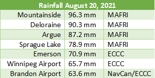
August 20 was the rainiest day for most of southern Manitoba. Winnipeg Airport received 65.7 mm, the wettest day since 2000 and the wettest August day since 1993. It was also the 6th wettest August day on record since 1873. Brandon received 63.6 mm, its 3rd wettest August day on record since 1890. Interestingly, the downpours did not produce as much lightning as you would have expected with the rainfall rates. Winnipeg Airport received 41.5 mm in a one hour timeframe, potentially a new August record, or second place to August 13, 2010. It is difficult to confirm the record because I do not have access to hourly rainfall amounts going back to 2010. The 2010 event dropped anywhere from 41 to 43 mm in an hour. Other parts of southern Manitoba recveived even heavier rain during the August 20, 2021 event. Amounts approaching 100 mm were recorded in some places, as seen in the following list.
The wetter and cooler conditions allowed the province to finally lift some backcountry travel and fire restrictions, and provided firefighters some relief.
7 - Prolonged February Cold Snap
After a very mild January, February came in like a wrecking ball, bringing with it the only extended period of anomalous cold this year. And this wasn't just the case for Manitoba, it was a cold snap that covered most of the continent all the way down to the Gulf of Mexico. At one point on February 14, the entire state of Texas was under a winter storm warning, with snow and subfreezing temperatures all the way to the Mexico border. In fact, on February 15, temperatures down to -10°C were recorded close to the Gulf Coast and Mexico border, with temperatures in the -20s in northwestern Texas and Oklahoma. Dallas and Oklahoma City both had their 2nd coldest temperatures on record with lows of -19°C and -26°C respectively. Snow and ice caused millions of power outages in what was one of the most devastating power disasters on record. Almost all of Texas was covered in snow and ice and highways were very quiet as people stayed home.
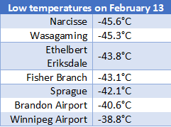
In Manitoba, it was mostly just cold. Winnipeg saw 9 consecutive days with daytime highs below -20°C, the longest such streak since 1996 and tied 17th longest since 1872. Five of these days did not even rise above -25. On February 6 and 7, there were 41 consecutive hours of wind chill below -40, the longest such period since 2014. February 13 saw the worst cold, with a high of -26.0°C and low of -38.8°C. Both of these values were record lows for the date. Wind chill dipped to -50 as well, the latest date in the season to do so since 1967. Only 1962, 1966 an 1967 had wind chill below -50 later than this date, since 1953. Other parts of southern Manitoba were even colder, with lows below -40 in many places. In northern Manitoba, lows dipped to -46°C in some places during the cold spell. Regina, SK recorded over 100 hours consecutively with wind chill below -40.
6 - Warm Fall Provides an Extended Growing Season
Warm conditions from the summer continued into the fall across southern Manitoba. The most anomalous warm spell occurred in the final days of September and in the first week of October, with summerlike temperatures above 30°C making a return.
 |
| Flowers still blooming Sept 24 at St Vital Park |
On September 28 and 29, three temperatures records were broken in Winnipeg - two record highs and a record high minimum. A maximum of 31.5°C on the 29th was the latest date on record to reach that high and tied with 1905 for 5th latest date to reach 30°C. Even more remarkable was the humidity that accompanied the heat, with humidex values reaching 36. This was the latest date since 1953 to have humidex over 35, beating September 26, 2014. Temperatures were even higher in other places. Parts of southeastern Manitoba exceeded 32°C, with a maximum of 33.1°C in Beausejour. Humidex values also reached as high as 37. Southern Saskatchewan reached as high as 34°C on the 28th, with Melita hitting 32.5°C. In Western North Dakota, temperatures reached as high as 100F (over 37°C).
The heat continued into the first week of October, which was the 3rd warmest on record in Winnipeg, averaging 16.7°C. Daytime highs tied with 2011 for warmest on record, averaging 25.3°C. The 7 consecutive days above 20 was tied with 1914, 1943 and 2011 for 3rd longest such streak in October since 1872. Most were 11 days in 1963 and 8 days in 1909 and 2010. Winnipeg narrowly missed 30°C on October 5 with a high of 29.7°C, the 5th hottest October day on record since 1872. Brandon Airport broke its all-time October high temperature record (records since 1941) twice with highs of 31.7°C and 31.5°C on October 5 and 6. Note that Brandon CDA hit 32.5°C on Oct 1, 1992.
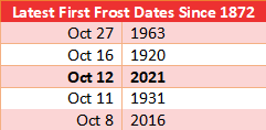
Thanks to continued warmth, the first frost was significantly later than normal. Winnipeg Airport did not freeze until October 12, the 3rd latest first frost on record since 1872 in Winnipeg. However, within the city, the frost was even later. The Forks did not freeze until October 20. The extended growing season meant gardeners were still harvesting well into October as plants continued to grow. However, the late season warmth also meant some grass fires continued to develop into October.
It was the warmest October since 1963 with a mean temperature of 8.7°C, and the 10th warmest since 1872. September tied with 2015 for 6th warmest September since 1872, averaging 15.8°C.
The warmth even continued into early November with temperatures reaching the mid to high teens across southern Manitoba on the 6th. Winnipeg Airport hit 16.1°C. The provincial hotspots were Deerwood and Carman with highs of 17.3°C.
In the end, fall (Sep to Nov) 2021 tied with 1953, 2011 and 2015 for 5th warmest fall since 1872, averaging 7.3°C. 30 days exceeded 20°C, tied 2nd most with 1897, 1914 and 1938, behind only 38 days in 1963.
5 - Warmest March Since 2012 Ends One of the Shortest Winters Ever Recorded
Despite a brutal cold spell in February, spring came remarkably early in 2021. Snow was already gone by the second week of March and temperatures were already reaching double digits. River ice already began breaking away, golfers were out and the wild fire season began early. All this was quite reminiscent of March 2012 and 1878, the two warmest Marches of all time. Really, the only difference was that March 2021 was very dry, while 1878 and 2012 had significant rainfall amounts. This resulted in overnight lows being less impressively warm than the daytime highs. .
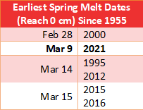
In Winnipeg, snow depth reached 0 cm on March 9, the 2nd earliest spring melt date on record since 1955, behind only February 28, 2000. Note that snow depth likely reached 0 cm earlier in 1878, which would actually make 2021 the 3rd earliest known spring melt date.
 |
| Snow was almost gone south of Winnipeg as early as Feb 22 (Emerson webcam) |
With the snow disappearing much earlier than normal, temperatures were quite mild in March. With a mean temperature of -0.4°C, March was 6.5°C above normal and the 6th warmest since 1872. Only 6 days dipped below -10°C, the 3rd fewest since 1872 and the fewest since 1973. The warmth was impressive throughout most of the month, but was most impressive on March 8, March 20 and March 29. Winnipeg broke temperature records on each of these days.
On March 8, a high of 14.4°C obliterated the old record of 6.7°C in 1902. It was the 2nd earliest date to reach 14°C since 1872. March 6, 2000, with a high of 16.5°C, was the only other date. The highest temperatures were south of the city with maximums of 15.9°C in Emerson, 15.3°C in Gretna and 15.2°C in Altona. In North Dakota, highs between 16 and 18°C were recorded from Grand Forks to Fargo.
Another push of warm air March 19 to 21 brought temperatures into the mid to high teens. On March 20, a high of 17.3°C broke the old record of 13.9°C in 1878. Again, temperatures were warmest south and southwest of the city with maximums of 18.5°C in Winkler and 18.3°C in Carman. This particular warm spell was most extreme in Saskatchewan on March 19. Several locations exceeded 20°C, marking the earliest date to reach 20°C on record in some locations. Moose Jaw, SK, reached 21.9°C, breaking the previous earliest 20°C of March 20, 1910. Regina reached 20.9°C, breaking the previous earliest 20°C of March 22, 1928.
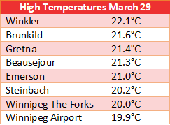
Then came the warmest weather of the month on March 29. Winnipeg Airport reached 19.9°C, breaking the old record of 18.2°C in 2010. This narrowly missed the official 20°C mark, but was still tied with March 17, 2012 as the 7th warmest March day on record since 1872. Some stations across the city did hit the official 20.0°C mark however, such as The Forks with a high of 20.0°C. South of the city, temperatures above 20°C were widespread, even reaching as high as 22°C. South of the border, Fargo, ND hit 25°C and Grand Forks 23°C.
The early spring, combined with little winter snowfall and a dry March, caused an early fire season across southern Manitoba. March was driest south of the Trans Canada, with regions from Melita to Emerson seeing anywhere from a measly 0.2 mm to 2.0 mm of precipitation. Fire bans and backcountry travel restrictions were already put into place in mid-late March and early April. Numerous grass fires occurred, including one in the Charleswood neighbourhood of Winnipeg. In Piney, burn bans were announced as soon as March 24. On the evening of March 17, hundreds of hectares of land were burned in the Taché municipality. On March 18, more fires occurred along the US border near Vita. On April 7, four buildings were damaged by fire near Lorette.
 |
| Photo taken by Andy Brandt from a drone, posted on Steinbach Online |
The early spring meant early ice breakup as well. This caught some people off guard unfortunately. One man died while attempting to cross the Winnipeg River on March 18. Another man died while attempting to cross the Red River in Selkirk on March 21. Both men fell through the thin ice.
4 - 2nd Warmest January on Record Since 1873
It was a very slow start to winter as temperatures remained well above normal in both December and January. With a mean temperature of -10.4°C, it was the 2nd warmest January on record since 1873, behind only 2006. The first half of winter was in fact quite reminiscent of the warmest winter on record in 1877-78. Daytime highs from November to January were the warmest on record, averaging -2.0°C, beating -2.2°C in 1877-78. Temperatures in January did not dip to -20°C until the 18th, tying with 2006 for the latest. The first two weeks of January were the warmest on record, averaging -4.8°C. In total, only 7 days dipped below -20°C in January, the 2nd fewest. Only 2006 saw fewer with 3 days. Normal is 18 days.
Thanks to the warmer temperatures, rain was seen in January as well. There were three days of rain at Winnipeg Airport, however, they only amounted to 0.4 mm. Brandon, on the other hand, received 2.2 mm of rain (and freezing rain) on January 13 alone. This was a new daily rainfall record for January, beating 2.0 mm on Jan 11, 1928 and Jan 15, 2006.
3 - Relentless Summer Heat and the ''Heat Dome'' - Deadliest Canadian Weather Event
Summer 2021 was the hottest on record since 1900 for the US and Canada combined, according to data from NASA. Western parts of the two countries were especially hot, with a vast area recording its hottest summer on record. Both Calgary and Edmonton had their hottest summers. Southern Manitoba was on the fringe of the record heat, recording many hot days, but not enough to be the hottest summer. It was still an impressive summer however. In Winnipeg, with a mean temperature from June to August of 20.2°C, it was tied with 1955 for 4th hottest summer since 1873. Summer 2021 was in many ways quite similar to summer 1961 for southern Manitoba. In Winnipeg, both recorded record numbers of 30°C days, record amounts of smoke, and extreme dryness. Really, the only reasons this year wasn't the hottest summer was because of the smoke inhibiting maximum heating in July, and the cooler and wetter conditions in the second half of August.
Winnipeg Airport recorded 35 days above 30°C this year, tied with 1988 for the most 30°C days on record.

The summer started hot right from the getgo, with record heat June 4 and 5 across southern Manitoba. In fact, some of the hottest temperatures ever recorded in the province occurred during this heat wave. Temperatures exceeded 40°C in southern parts of the Red River Valley, south of the Trans Canada. The hottest temperature was 41.3°C in Gretna, the hottest temperature recorded in Manitoba since August 6, 1988 when Starbuck hit 41.5°C. It was early in the season to achieve these temperatures as well. Only one other time in recorded history has temperatures exceeded 40°C this early - 42.2°C on May 30, 1934 in Morden. Most 40°C days in the province have occurred in July and August. Temperatures had also risen very quickly, which was similar to mornings in July 1936, the month that featured the worst heat wave in the province's history. Winnipeg recorded the hottest 9 am, 10 am and 11 am temperatures on record since 1953. I had posted a detailed summary of this heat event which can be viewed by clicking this link.
From then on, it remained hot basically right through to mid August. At Winnipeg Airport, June tied 10th warmest since 1872 and July was tied 9th warmest. Daytime highs were the winners, with June highs averaging 27.5°C, tied with 1961 for 4th hottest on record. July highs averaged 29.5°C, the 3rd hottest on record and only the 8th month to ever average above 29°C. 16 days exceeded 30°C in July, tied with 2006 for 2nd most. The June to July period averaged 20.9°C, tied with 1923 for 2nd warmest on record. On August 16, Winnipeg Airport recorded a minimum of 22.2°C, the 3rd highest in August since 1873 and the highest recorded since 2007.
''Heat Dome'' was a term coined in late June for a massive ridge of high pressure in western Canada which produced the worst heat wave in Canadian history, and deadliest weather event in Canadian history. Some 570 deaths were recorded in BC directly related to the heat. The all-time Canadian heat record of 45.0°C in Saskatchewan in 1937 was broken three times in the BC interior. Temperatures approached the unthinkable, with a maximum temperature of 49.6°C in Lytton, BC on June 29. The heat was seemingly never ending, with day after day of temperatures above 30°C and overnight lows above 20°C. This included Alberta, which is a province unaccustomed to extreme heat and humidity, proven by a low number of residents with air conditioning. Air conditioning sales, of course, exploded as a result of the heat wave with long wait times for installation and purchase. Edmonton had 4 consecutive days above 34°C and 3 consecutive days with overnight lows above 20°C, very rare for the city. The daily low of 23.4°C on July 1 was the highest the city has ever seen, eclipsing the previous record of 21.4°C on July 14, 2007. The city hit 37.0°C on June 30, only the second time in its history to reach 37°C. The extreme heat provided the conditions for devastating fires in BC. Some fires grew so intense that they generated their own thunderstorms, and one of these fires unfortunately burned down the town of Lytton.
 |
| July 16 satellite image of Prairies showing widespread smoke |
The extreme heat and humidity had even extended into far northern Alberta and the Northwest Territories. The jet stream had advanced so far north, that multiple waves of thunderstorm complexes moved through the region as well, while the Prairies and BC remained exceptionally dry. On June 30, Fort Smith, NWT reached 39.9°C and an absolutely stunning humidex of 50. It appears the previous humidex record for NWT was 45 (Patrick Duplessis). The high of 39.9°C was also the highest ever recorded in NWT. Once again on August 1, parts of NWT broke all-time August heat records with highs approaching 35°C.
2 - A Very Warm Year
2021 was a very warm year, particularly for daytime highs. Highs averaged 10.9°C, the 2nd warmest on record since 1873, behind only 11.1°C in 1987. Mean temperature was 4.5°C, tied with 2006 for 7th warmest year since 1873. 2012 and 2016 were even warmer, averaging 4.6°C. 6 out of 12 months in 2021 averaged more than two degrees above normal, while only one averaged more than one degree below normal.
All four seasons in 2021 were 22nd warmest or warmer: winter 2020-21 was tied 14th warmest, spring was tied 22nd warmest, summer was tied 4th warmest, and fall was tied 5th warmest.
6 of 12 months in 2021 were in the top 10 warmest on record: January 2nd warmest, March 6th warmest, June 10th warmest, July 9th warmest, September 6th warmest and October 10th warmest.
1 - Exceptional Drought and 4th Worst Fire Year in Manitoba Since 1914
The Winnipeg Area has been, overall, very dry since 2017, but 2021 was really when the drought became widespread across all of the Canadian Prairies and the Northern Plains of the US. The widespread and severe drought in combination with above normal temperatures caused waterways to drop to levels not seen in decades, posing a challenge for farmers and some municipalities. The dry conditions also caused an active fire season which choked much of Manitoba with smoke for much of the summer.
Highlighting the prolonged nature of the drought, Winnipeg had 21 consecutive months of below normal precipitation at the Airport, which was unprecedented since records began in the city in 1872. Every month from November 2019 to July 2021 was drier than normal, with the city only seeing 54% of normal precipitation through the period. This represented an almost 400 mm deficit. The old record was, in fact, closer to the beginning of this prolonged dry spell which began in 2017: a streak of 11 months of below normal precipitation from October 2017 to August 2018.
Exceptionally low river levels were seen much of the year. In Winnipeg, the low water levels exposed previously submerged relics, such as an old car and ancient bridge pylons near The Forks (see photo below by Ian McCausland from early November - also Dan Harper's aerial video). In May, masses of glass were also seen along the Red River near the locations of old breweries from a century ago. The Red River in the city was 3 feet lower than the previous record for mid May back in 1981.
 |
| By Ian McCausland (Twitter), a professional photographer |
In general, the whole water system in the province has been well below normal; not just rivers but also the Manitoba lakes and soil moisture. According to Manitoba Infrastructure, Lake Manitoba dropped to its lowest level in history. As a global picture, the province has not seen a situation this dire since the Dirty Thirties, and the Minister of Infrastructure and Emergency Measures declared this a once in 700 year drought. Above normal snowfall this winter and perhaps rainfall next year will be necessary to avoid economic disaster. Agriculture and Agri-Food Canada declared exceptional drought in southern Manitoba, a designation defined as having a recurrence interval of twice a century. Due to low river levels, Holiday Mountain Ski Resort declared they would not open in winter 2021-22 due to an inability to produce enough artificial snow.
 |
| Roseau River near Dominion City in early August, by Brenda Max (Facebook - see more photos) |
 |
| Lake Diefenbaker in Saskatchewan in late July, by Terri Lang (Twitter), meteorologist |
Some rural municipalities declared states of agricultural disaster due to drought conditions. For ranchers, inadequate soil moisture meant it was difficult for grass to grow. Cattle had to be moved around or sold off across the Prairies and in North Dakota. Some ranchers went out of business altogether. This was exacerbated by the fact there have been several dry summers in a row. If drought wasn't enough to stunt crops, some areas saw larger than normal numbers of pests such as grasshoppers, which ate away at what little crop was there. Drought and heat also reduced honey production and devastated U-pick berry farms.
It was a year with numerous fires, fire bans and backcountry travel restrictions. There were several evacuations, including in Nopiming Provincial Park and in several First Nations communities. Firefighters from all over came to battle the fires, including from Ontario, NWT, Alberta, Quebec, Nova Scotia, New Brunswick and South Africa. The Canadian Military also helped extinguish fires. Some fires were some of the largest ever seen in the province. The three largest fires by area burned are listed below, pulled from the Manitoba Conservation and Climate website. In total across the province, 1,266,775.6 ha of land was reported burned in 2021, the 4th worst fire year on record since 1914 and the worst since 1994.
May - East of Waterhen Lake - 206,000 hectares
 |
| Visible satellite image showing fires and large burn scars in MB Interlake on May 19 |
With the exceptional fire year, smoke was a common feature of 2021. With 265 hours of smoke at Winnipeg Airport, it was by far the smokiest year since 1961 and the 3rd smokiest year on record since 1953. Much of the smoke occurred in July and August with 242 hours, the 2nd smokiest summer since 1953. July was the smokiest on record with 137 hours of smoke, eclipsing the previous record of 79 hours in 2015. Special air quality statements were issued for Winnipeg on 25 days this year.
 |
| A typical summer 2021 sky in Winnipeg - Photo by Tyson Koschik / CBC |
With 393.9 mm of precipitation, 2021 was the 16th driest year on record since 1873. 4 out of the past 5 years have been in the top 17 driest, which highlights how prolonged this dry spell has been. In fact, the past 5 years were easily the driest 5-year period on record since 1873 with a total of 1927.9 mm of precipitation. The previous record was more than 100 mm away at 2054.1 mm from 1885 to 1889. Even if we assumed snow at 10:1 ratio, as was the case back in the 1880s, 2017-2021 would still rank as 2nd driest 5-year period.
Several milestones or impressive rankings were set for dryness in 2021:
- 3rd driest winter and tied 4th driest February
- May 12 relative humidity 10% - lowest on record in May since 1953, beating 11% in 1978, 1980, 1982. Tied with April 1977 and 1980 for lowest relative humidity for any month since 1953.
- Driest second half of June on record with only 0.1 mm of rain. Beats 0.5 mm in 1874 and 1912.
- 5th consecutive year to have a top 21 driest first half of the year (January to June)
- 2nd driest January to July period with 148.7 mm. Driest was 140.9 mm in 1980.
- Driest 12-month period on record. 264.2 mm of precipitation from Aug 2020 to Jul 2021 beats 275.3 mm from Sep 1885 to Aug 1886.
- Driest July on record with 8.5 mm. Beats 10.0 mm in 2011.
- 8th driest September with 12.6 mm.
- 3rd fewest thunderstorm days since 1953 with only 15 days in 2021 - fewest since 1967. We still have not had an above normal thunderstorm season in Winnipeg since 2007.
No comments:
Post a Comment