Monday 28 December 2020

Top 10 Weather Stories of 2020 - Winnipeg Area


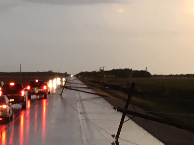
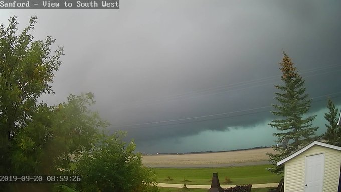
 10 - September 6 Damaging Wind Event

A low pressure system moved through southern Manitoba on September 6, producing damaging northwesterly winds on its back side. Wind gusts over 80 km/h knocked down trees and tree branches, commercial signage, fences and power lines. More than 19,500 customers lost power at some point due to the winds, from Pilot Mound to the Whiteshell and from the US border to Victoria Beach. More than 5,000 were still without power the next morning. Large waves and associated storm surge on Lake Manitoba and Lake Winnipeg also caused some damages along shorelines, such as to docks. Storm surge over 1.5 metres was predicted by the province. 


9 - Snowiest April in 17 years

As has been the story of the past decade, April continued to be cold and snowy in 2020. This time, the story was especially the above normal snowfall. A total of 29.8 cm fell in Winnipeg, the snowiest April since 2003 and the 14th snowiest since 1872. The snow was spread out over mostly two events on Apr 2-3 and Apr 8. 

During the Apr 2-3 event, 22.0 cm of snow fell in Winnipeg, the 7th largest 2-day snowfall in April since 1872. It was also the largest April snowstorm since 1999. 18.0 cm fell on April 2 alone, breaking the previous daily record of 9.8 cm in 1999. The storm system also spread heavy snowfall throughout the remainder of southern Manitoba, the Dakotas and parts of Saskatchewan. 25 cm fell in Grand Forks, ND.

On April 8, a small convective complex moved through the Red River Valley early in the afternoon producing impressive snowfall rates. 6 cm of snow fell at the Charleswood site in Winnipeg in only 1 hour. The snow quickly melted afterward with the sunshine. These higher snowfall amounts were quite localized given the convective nature of the event.

Visible satellite showing small convective snow complex through RRV April 8 posted by Rob

April was also cold with a mean temperature of 1.7°C, tied 35th coldest and 2.8°C below normal. Thanks to a cold decade for Aprils, the month of April has cooled 0.7°C in the 1991-2020 normals compared to the 1981-2010 normals. It is tied with February for cooling the most. This is a large change in a short period of time, representative of a sudden or rapid change in climate. 


8 - Record Late-Season Warmth and Humidity Highlights Warm Start to November

After a very cold second half of October, things turned around in the first 8 days of November to much warmer than normal. The first 8 days averaged 4.9°C, tied 11th warmest since 1872. Daytime highs were the most abnormally warm, averaging 13.0°C. This was about 10 degrees above normal, the 3rd warmest on record and warmest since 1975 for the period. 3 days exceeded 18°C, tied with 1903 for most in November since 1872. It was even warmer the further south you were. In Fargo, ND, 3 days exceeded 21°C (70°F) in November for the first time on record. On the Manitoba side, Emerson exceeded 20°C three times.

The abnormal conditions peaked on November 8, when a strong low pressure system moved into Manitoba from south of the border, briefly ushering in an unseasonably warm and humid air mass into southeastern Manitoba and the Red River Valley. As the warm front advanced northward, skies cleared and temperatures quickly climbed to close to 20°C. Combined with dewpoint values in the low double digits, this produced humidex values in the low twenties. These types of conditions were unprecedented this late in the season in Winnipeg. In fact, since 1953 there is no other comparable event, with this level of warmth and humidity, after October 27 (in 1989). The unusually high amount of humidity combined with cool surfaces resulted in condensation on roadways

Graphical area forecast (GFA) issued by CMAC-W at ECCC valid 00Z Nov 9

The maximum temperature of 19.2°C at Winnipeg Airport on November 8 broke the daily record of 17.5°C in 1999 and was the latest date since 1872 to reach or exceed 19°C. Previously, the latest date was November 5. Dewpoint values reached 10.6°C, eclipsing the previous daily record of 6.7°C in 1969. It was the latest date to reach a double digit dewpoint since 1953, beating the previous latest date of November 7 set in 2016. Humidex reached 20.3 as well, only the second time since 1953 that humidex reached or exceeded 20°C in November. The only other time was on November 5, 1975. However, that occurrence was due to temperature solely, not due to humidity. Temperatures and dewpoints were even higher in southern parts of Winnipeg and south and east of the city. Temperatures reached as high as 21.4°C in Sprague, and dewpoint values as high as 13-14°C were observed

The same system that brought the warmth and humidity on November 8 wrecked havoc throughout the rest of the Prairies. A massive blizzard crippled Saskatchewan and southern Alberta with 30 to 50 cm of snow and wind gusts up to or over 70 km/h. Saskatoon was among those hardest hit as the storm basically shut down the city and forced the city to postpone the municipal election. Flights were also cancelled, transit was suspended and leisure centres were closed. In western and central Manitoba, the system brought an exceptional ice storm with several hours of freezing rain that was heavy at times over a large area. Travel was trecherous with reports of rollovers. Power lines were sagging or downed, causing power outages

McCreary, MB freezing rain Nov 9, by Josiah Preuter on Twitter


7 - Hot and Humid Summer

To those who like summer weather, it was one of the nicest summers anybody could have asked for in Winnipeg. It mostly stayed warm right through June, July and August. Daytime highs averaged 26.4°C, tied 15th warmest. Overnight lows averaged 12.9°C, tied 18th warmest and the warmest since 2005. The mean temperature was 19.7°C, 1.3°C above normal and tied 15th warmest summer since 1873. 19 days exceeded 30°C during the 3-month period, 7 days above normal and tied 26th most since 1873. From June 23 to August 13, not a single day had a high cooler than 23°C, an amazing 52-day streak. In fact, the coolest day in July was 23.3°C, highest since 1964 and tied 3rd highest since 1873. 

A perfect summer for the beach

June was the most above normal month, averaging 18.7°C, tied 22nd warmest since 1872. Highs were most abnormal, averaging 25.4°C, 2.3°C above normal and more typical of July. 8 days exceeded 30°C, tied 12th most since 1872, and 6 days more than normal. The warmth peaked on June 17, when temperatures remained abnormally warm through the night. It was still 27.0°C at 4am, the warmest 4am temperature on record in June since 1953, and tied with August 1988 for warmest 4am temperature of all-time since 1953. 27.3°C at 3am also tied with 1996 for warmest in June since 1953. 

July remained above normal, averaging 20.9°C, tied 25th warmest since 1873. Lows were most abnormal, averaging 14.7°C, 17th warmest. It was also tied for 5th most humid July since 1953, with an average dewpoint of 15.4°C. On July 24, Winnipeg reached peak #Mexipeg status as dewpoint values reached 25.1°C at the Airport, the 12th day of dewpoint over 25°C since 1953. It broke the daily record of 23.6°C in 1997. 25°C dewpoints have become increasingly over the past decade or two, now occurring about once every 3 years on average. 

The warmth continued in August, albeit not as extreme relative to normal. With a mean temperature of 19.5°C, it was tied 34th warmest August. 

South of the border, the summer was even more extreme in parts of North Dakota. In Fargo, ND, every single day in June, July and August exceeded 21°C (70°F) for the first time on record since 1881. Overall, the summer was tied with 1976 for 5th warmest since 1881 with a mean temperature of 21.8°C (71.3°F). Bismarck, ND recorded its 3rd warmest summer with a mean temperature of 22.6°C (72.7°F). 


6 - Delayed Spring Greenup Thanks to Unseasonable Cold in the First Half of May

It was a delayed spring for southern Manitoba in 2020, as temperatures dipped to record cold values in the first half of May. With several nights falling well below freezing, spring growth was stunted as gardens would not grow and grass would not green up as quickly as normal for May. Once it finally warmed up later in the month, green up resumed quickly as we transitioned to summer in little time. The first half of May (May 1 to 15) was the 9th coldest on record since 1872, with a mean temperature of 4.6°C, 4.8°C below normal for the period. 

The cold was at its worst May 7 to 13. A total of 12 cold-related records were broken during this period at Winnipeg Airport: two record low temperatures, three record low wind chills, and 7 record low dewpoints (3 record lows and 4 record low maximums). The low of -10.3°C on May 11 was the coldest temperature for so late in the season since 1872, and the second latest date to dip into the minus double digits. Wind chill values dipped to -15.2 on the same date, the latest date since 1953 to see wind chill below -14 and eclipsing the daily record of -10.4 in 2005. 

The dewpoint values were the most extreme during the cold spell, showing the exceptional dryness of the air for that time of year. The all-time (since 1953) lowest dewpoint record for May was broken twice, first on May 11 with -16.2°C, then on May 12 with -16.8°C. The previous record was -16.1°C on May 2, 1967. The fact these records occurred 10 days later in the season again proves the extremeness of the event. The records also broke the previous daily records by around 5°C. In addition, the maximum dewpoint on May 12 was only -10.9°C, the lowest on record for May since 1953, beating -9.8°C on May 6, 1989. It was also 6°C lower than the previous daily record set in 2013. 

In spite of the cold, Winnipeg managed to avoid any snow in May. However, a clipper system on May 9 dumped 5 to 10 cm throughout southwestern Manitoba, including in Brandon. 

Webcams through SW MB showing snow morning of May 9, via robsobs


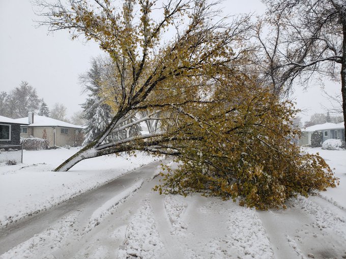
5 - Yet Another Cold October

It was yet another cold October across southern Manitoba. In fact, it was the third consecutive October to be in the top 30 coldest on record since 1872 in Winnipeg. This is the first time we've had three consecutive such Octobers, making it the coldest 3-year period for Octobers since 1872. The bulk of the cold was in the second half of the month (Oct 15-31) which was the 3rd coldest on record since 1872:


No temperature records were broken during the month, highlighting the persistence of the cold rather than the extremeness of it. However, one record low wind chill occurred, in addition to two record low maximum dewpoint records. 

October was dominated by the cold in the second half. As a result, the month as a whole was tied with 1991 for 7th coldest October since 1872, with a mean temperature of 1.8°C. That was 3.3°C below normal, and tied with 1991 for 3rd coldest October in the past 100 years. Overnight lows were the most extreme relative to normal, averaging -3.8°C, tied 5th coldest on record since 1872. The average dewpoint was -3.7°C, 4.3°C below normal and the 3rd lowest since 1953. 

In addition to the cold, the month was snowy, but luckily not as snowy as last year. 14.4 cm fell, 2.6 times the normal, making it the 26th snowiest October since 1872 and the 5th snowiest in the past 40 years. Much of the snow fell during the night of October 20-21, with 8.0 cm. The snow depth of 8 cm the morning of October 21 was a daily record, and was one of the deepest for so early in the season since 1955. Since 1955, only 2009 and 2019 had deeper snow packs during the early morning hours on an earlier date in the season. The snow caused slippery road conditions with multiple vehicles reportedly in ditches along the Trans Canada west of the city. Lake effect flurries also occurred as early as October 1, west and east of the city, but luckily missed the city. 

The persistence of the cold weather pattern in October also resulted in persistent snow squalls off the lakes. Berens River was particularly hard hit with one of the snowiest months it has ever recorded. An estimated 91 to 105 cm of snow fell, mostly between October 17 and 26. Values are estimated and an exact value cannot be determined given the absence of a snow observer. Estimations are based on automated snow depth sensors in addition to weighing gauge precipitation amounts. The snowiest event started in the morning of October 17 and ended overnight on October 19, with most of the snow falling on October 18. Around 50 cm of snow fell during this event. Snowfall rates as high as around 6 cm per hour occurred. In addition, wind gusts reached up to 60-70 km/h at times, producing blowing snow and making snowfall amounts even more difficult to estimate. Snow on ground peaked at 64 cm in the evening of Oct 25, and at least 25 cm would remain on the ground right through the remainder of the year. 

Berens River Airport burried by snow squalls. Webcam Oct 25, via Nav Canada


4 - Warm Winter, and Year, with Few Days Below -20°C

In general, 2020 was a year of warm winter months with a very notable lack of cold days. There were only 32 days below -20°C in 2020, tied with 1878, 1915 and 2006 for 3rd fewest on record since 1872. It was 21 days fewer than the normal of 53 days. 


Winter 2019-2020 was tied 24th warmest since 1872 with a mean temperature of -12.8°C, 1.7°C above normal. There were only 35 days below -20°C, tied 13th fewest since 1872. There were only 4 days of -30°C, tied 10th fewest. Normals are 45 days and 13 days respectively. The winter continued a long-term trend toward fewer very cold days in Winnipeg. Over the past decade, Winnipeg averaged 9 days of -30°C per year, significantly less than the 1981-2010 normal of 14 days. 

January 2020 was the 12th warmest on record since 1872 with a mean temperature of -12.5°C, 3.9°C above normal. Daily lows were even more impressive, tied 10th warmest with an average low of -16.7°C, 4.8°C above normal. With just 1 day of -30°C and 10 days of -20°C, these were tied 5th fewest and 6th fewest respectively, since 1872. February was near normal but still mild historically at 34th warmest. Interestingly, the AO index reached its highest daily value on record since records began in 1950, of +6.5 on February 21. 

Thanks to warm winter months, as well as summer months, 2020 was tied 18th warmest year on record since 1873 with a mean temperature of 3.6°C, 0.7°C above normal. The climate remains the warmest it has ever been, with the new 1991-2020 normals continuing with an average yearly mean temperature of 2.9°C.


3 - Mild, Rainy First Half of December with Bare Fields

Real winter wasn't anywhere to be found across southern Manitoba in the first half of December, which felt bizarre given the development of a moderate to strong La Niña this winter. Temperatures were persistently mild, it rained more than it snowed, and snow was difficult to find as fields remained mostly bare throughout a large portion of southern Manitoba. This kind of weather was more typical of the first half of November. The snow and cold did finally reach Manitobans just before Christmas, but not before some impressive numbers came out of the warm spell. 

Every single of the first ten days of the month exceeded the freezing mark at Winnipeg Airport, the first time on record this has been observed in the city since 1872. In fact, the first ten days of December were the 3rd warmest on record since 1872 with a mean temperature of -2.2°C, almost 10°C above normal. Only 1913 and 1939 were warmer, both of which had a green Christmas. Daily highs averaged 3.1°C, the 2nd warmest since 1872. Only 1939 was warmer with a 3.6°C average. Despite the extreme warmth, only one temperature record was broken: a high of 6.7°C on Dec 8 broke the old record of 5.6°C in 1928 and 1939. Some instances of double digits did occur in southern Manitoba during the wram spell, such as 10.1°C in McCreary on Dec 8. 

3rd warmest first 10 days of December since 1872, image by Rob Paola on Twitter

During the first 12 days of the month, only one day dipped below -10°C and the coldest temperature was only -10.6°C, amazing when you consider the normal high for the period is close to -8°C or so. The ten-consecutive days of highs above freezing also broke the previous longest December streak of 8 days in December 1877, which was Winnipeg's warmest December on record. However, that 1877 December did had 11 consecutive days with temperatures at or above freezing (0.0°C or above). 

There was barely any snow to be seen across southern Manitoba throughout the period with only small patches here and there, mainly in ditches and shaded areas. The Winnipeg Charleswood site recorded trace snow depth for most of the first 12 days of the month, with snow depth dropping to 0 cm on Dec 10 and 11 thanks to rainfall. Only 6 other years since 1955 have seen 0 cm snow depth that late in the season: 1974, 1982, 1987, 1998, 1999 and 2002. This averages out to about once per decade. 

Rosser webcam just NW of Wpg on Dec 11 showing no snow on ground

On the night of Dec 9-10, a clipper system moved through southern Manitoba dropping with it a rare December steady rainfall. 4 to 5 mm of rain was recorded in Winnipeg, with a rate of just over 1 mm per hour recorded at the peak of the event. The only other comparable rainfall events occurring this late in the season were in 1877, 1939 and 1959. Rain and freezing rain/drizzle occur often in the middle of winter, but rarely of this intensity and amount. The highest rainfall amounts actually fell south of the Trans Canada with a general 6 to 12 mm observed. Rainfall rates were as high as 2-3 mm per hour through that swath. 


Some cold weather finally arrived just before Christmas, with Winnipeg's first -20°C of the season observed the night of Dec 13-14. Dec 14 ended a 20-day streak of above normal temperatures. 

In the end, December averaged -8.4°C, tied 12th warmest since 1872. Highs were even more extreme, averaging -3.3°C, tied 6th warmest. In addition, after another 0.4 mm of rain on Dec 19, December became the 6th rainiest on record since 1872 with 4.4 mm. It was also the rainiest since 1987. 


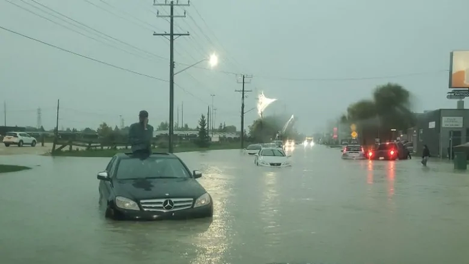
2 - Summer of Floods & Tornadoes in Southern Manitoba, but Uneventful in Winnipeg

It was yet again another benign summer weather-wise in Winnipeg. There were only 21 thunderstorm days at the Airport in 2020, the 4th consecutive year to see below normal thunderstorm activity (normal 26 days) and the 12th below normal year in the past 13 years. There were still some significant thunderstorm events in parts of southern Manitoba however, with damaging floods and tornadoes that were the biggest weather events of the year across southern Manitoba. 

Flooded field between Portage & Elie. By Günter on Twitter.
On May 23, slow-moving thunderstorms brought localized flooding downpours west of Winnipeg. An ECCC volunteer observer reported 165.4 mm of rain in a matter of hours in Marquette. Localized amounts as high as 180 mm were reported. The downpour completely flooded fields in the area. Given the localized nature of the storms, rainfall amounts quickly decreased away from the storm, down to 10 to 15 mm in western parts of Winnipeg. The floodwaters from the localized storm drained away quickly, with rushing water in ditches being seen the following day in areas that barely got any rain from the storms. 

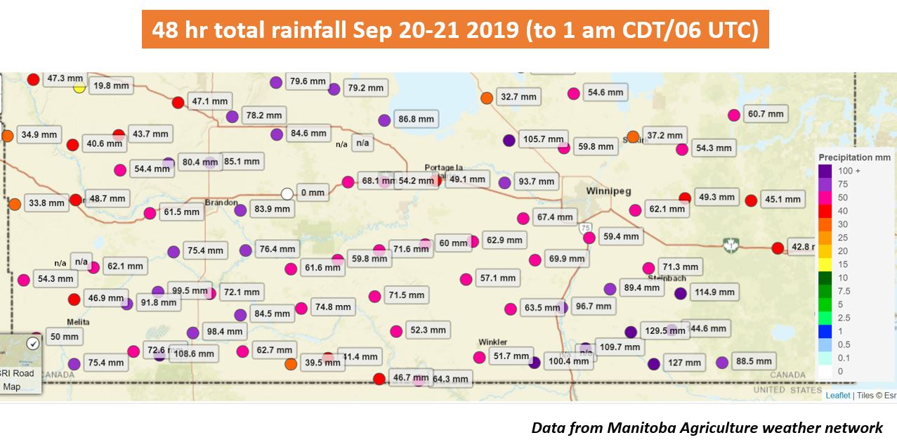
On June 7 and 8, a series of heavy thunderstorms pounded extreme southeastern Manitoba, dumping copious amounts of rain which lead to exceptional flooding. As much as 170 mm of rain fell in less than 36 hours, along with hail as large as ping pong balls. Here are some rainfall amounts from the event:


Severe flooding resulted from the heavy rainfall with RMs issuing states of emergency. Several roads were washed out and properties underwater. In fact, so many washouts occurred that some RMs were running out of barricades to close roads. Some residents that had not yet flooded scrambled to sandbag their homes before more rain and rising water levels arrived. Even after doing so, some residents voluntarily evacuated as water levels rose quickly and breached their homes. Levels along the Rat River were reported to be rising by as much as a foot per hour. At least 93 homes were forced to evacuate, due to rising water levels and road washouts preventing access to communities. The Reeve of Stuartburn called the flooding in his community the worst he has ever seen, even worse than 1997. It was an agricultural disaster with farmers losing their crops and ranchers struggling to feed their animals. It would take up to two weeks for the waters to recede. However, the state of emergency in the RM of Stuartburn did not end until July 8 and some residents still lived with the aftermath months later. Over half a million dollars in municipal infrastructure was damaged, with much more loss related to private property. 

Flood in SE Mb, by Steinbach Online with Mountain City Aviation


Brandon, by Quinn Melnyk
A series of thunderstorms in southwestern Manitoba June 28 and 30 caused exceptional flooding and a tornado. The worst of the events occurred in the afternoon and evening on June 28 when slow-moving and trailing storms along a quasi-stationary frontal boundary brought several hours of heavy and severe thunderstorms. A wide swath of 50+ mm of rain fell between Souris and the Interlake, with a swath of well over 100 mm from Brandon to Minnedosa. Brandon Airport recorded 155.5 mm of rain, easily making it the rainiest day on record since 1885 by eclipsing the previous record of 86.4 mm on May 6, 1964. This included 64.2 mm in just 1 hour from 5 to 6 pm. Streets overflowed with water onto properties in the city. Even higher rainfall amounts fell northwest of the city in the Rivers and Rapid City area. A remarkable 238.9 mm was recorded at Rivers-Pettapiece, an ECCC station approximately 5 km north of Rivers. This was slightly more than half an entire year's worth of precipitation in just a matter of hours, and was potentially the greatest single-day rainfall event on record in the province. Here are some rainfall amounts recorded with the event on June 28:

In addition to the rainfall, an EF-2 tornado narrowly missed Rapid City, but still damaged some properties just southeast of the village. Luckily, there were no injuries. Strong winds and large hail also occurred in some instances, with ping pong ball sized hail around Wasagaming, and gusts to 87 km/h in Brandon and 97 km/h at Moosehorn. 

Flooding from the widespread heavy rains was exceptional. Rivers swelled to levels not seen before and overland flooding blocked highways, flooded properties and washed out roads. The situation was made even worse by additional heavy thunderstorms two days later on June 30. Brandon received another 33.7 mm, while Forrest received 60.5 mm and Rivers-Pettapiece 62.6 mm. This meant some localities saw as much as 300 mm of rain in less than 3 days. 

In Minnedosa, about 60 people were forced to evacuate due to the Little Saskatchewan River overflowing its banks. High water levels destroyed a footbridge, washed out roads and flooded basements. The town also removed some of the logs from the local dam in order to release water from the lake to relieve pressure on the dam. Several municipalities throughout southwestern Manitoba issued states of emergency. In Rapid City, the dam along the Little Saskatchewan River breached. The breach means it can no longer hold water, causing concerns about wells in the area running dry because the province announced the dam would not be fully replaced until 2022. In the Rivers area, Lake Wahtopanah rose to record levels, flooding out properties along Chimo Beach. More than 100 people downstream of the Rivers dam were recommended to evacuate due to the province not being confident that the dam would be able to hold. Engineers remained on site 24/7 to monitor the dam. The Manitoba Infrastructure Minister called the flooding a once-in-1,000 year event. Luckily, the Rivers dam held throughout the event despite handling three times its typical water volume. The City of Brandon also made flood preparations in case of rising water levels along the Assiniboine. 

Flooded out road leading to Brandon Airport, by rcmpmb

Overland flooding also blocked off the road leading to Brandon Airport from the east. Anybody needing to access the airport was asked to detour from the west. Several sections of highways and grid roads throughout southwestern Manitoba were closed due to overland flooding, including sections of highway 10 and briefly the Trans Canada east of Brandon. Closures made it difficult for rural residents and farmers to get around and overland flooding destroyed some crops. Flooding also delayed the restoration of power after outages caused by the storms. 

Further east, a flood warning was issued for the Whitemud River, with the Town of Neepawa issuing a local state of emergency. The town had issued an urgent plea for volunteer sand baggers and some properties evacuated. The Park Lake dam in Neepawa also breached due to the flooding. The Portage Diversion was operated to limit water flow downstream of the Assiniboine. 

In the end, Brandon recorded 221.6 mm of rain in June, the 2nd wettest June on record. Interestingly, the wettest was not that long ago, back in 2014, with 251.6 mm. The Rivers-Pettapiece station recorded an unbelievable 340.0 mm. 

On August 7, a photogenic but deadly EF-3 tornado touched down near Scarth in southwestern Manitoba. Two vehicles along highway 83 were struck by the tornado, with Stars Air Ambulance being called to the scene. Two recent high school graduates from the Melita area died as their vehicle was tossed by the tornado. This was the first tornado-related death in Canada since the Alonsa, MB tornado in 2018, and the deadliest since 2009. It was also the first tornado to cause multiple deaths in Manitoba since the Rosa-St Malo tornado of 1977. The tornado also damaged a farm property, where luckily no one was home at the time, in addition to knocking over power lines. The driver in the second vehicle was also seriously injured as his vehicle was tossed by the tornado. 

1 - Driest Year on Record ?? Or 9th Driest ?

2020 was yet another exceptionally dry year in the series of dry years we have had the past decade. Due to undercatch of winter precipitation at the Airport, it is difficult nowadays to determine exactly how much precipitation has fallen. In my corrected dataset, I use The Forks whenever possible for snow-water equivalent as it undercatches significantly less than the Airport (possibly no longer an issue now due to a new gauge installed in November, but some time is needed to confirm this). Using this method, I end up with 304.8 mm of precipitation for 2020, which would make it the driest year on record since 1873, beating 320.9 mm in 1961. 

However, if we assume a 10:1 ratio throughout Winnipeg's climate history (1872-present), 2020 becomes the 9th driest year with 378.0 mm, and the driest since 1961. The reason for this difference is because snow-water equivalent measuring did not begin until the 1960s. Therefore, assuming a 10:1 ratio might be a more accurate way of determining the year's truer rank historically. 


Regardless, a number of milestones and impressive numbers were reached in 2020 with respect to the dryness:

  • 3rd driest February (2.8 mm)
  • 2nd driest winter (23.5 mm)
  • 15th driest spring (58.8 mm) and 14th least rainy (34.8 mm)
  • 33rd driest summer (172.0 mm)
  • 21st driest September (19.4 mm)
  • 18th least rainy October (5.9 mm)
  • 8th driest November (4.9 mm)
  • 3rd driest fall (39.4 mm) and 7th least rainy (26.6 mm)
  • 5th least rainy year (237.8 mm)
  • Driest year on record?? Or 9th driest?

The dryness of 2020 followed on the heels of the other exceptionally dry years of 2017 and 2018, and to a certain extent 2019 (except for the wet fall). 2017 was the 4th driest year, 2018 had the driest January to April on record and 2019 had the driest January to August on record. The long dry spell has caused soils to shift significantly in Winnipeg, causing damage to infrastructure such as sidewalks and homes. 

Subsiding soils causing damage to sidewalks


Thursday 2 January 2020

Top 10 Weather Stories of 2019 - Winnipeg Area

10 - Cold Late Spring with Early June Frost


After a very warm May in 2018, Mother Nature turned the tables in 2019 with the coldest May since 2009 in Winnipeg. It was especially the nights that were chilly with daily lows averaging 1.9°C, 2.4 degrees below normal and tied 17th coldest since 1872. Partly related to the cool conditions, no thunderstorms were recorded in May. Normally, 3 days would see a thunderstorm.

The chilly nights continued into the first couple days of June with Winnipeg Airport recording a low of -0.6°C on June 2, the first freeze in June since 2009. Once again, the station reached close to freezing on June 12 with a low of 1.0°C. Normally, the Airport sees its last freeze on May 24. June freezes have been uncommon since the 1970s with 2019 only being the 7th year with a June freeze since 1975.


9 - Dry December in the Northern Red River Valley


Dec 26 - not much snow on the fields west of Winnipeg
Most weather systems largely dodged the Winnipeg area and much of the Canadian side of the Red River Valley in December. However, south of the border it was a different story with storm after storm hitting the area. On December 29 alone, an intense Colorado Low brought a blizzard and over 30 cm of snow to Grand Forks and Fargo. The system had just clipped southeastern Manitoba with 5 to 10 cm, the largest snowfall of the month. Close to 60 cm of snow fell in Grand Forks in December, in sharp contrast to only about 20 cm in Winnipeg.  In Winnipeg, the 20 cm of snow that fell was very fluffy, resulting in little water equivalent. The snowfall (and some freezing rain) only amounted to about 5.7 mm of precipitation, making it tied for 8th driest December on record since 1872.

Snow on ground was quite meager throughout the month with grass blades still poking through the snow around Christmas. With about 7 cm of snow on the ground on Christmas morning, it was the lowest snow pack for the date since 2014. The month had started with only about 2 cm of snow on the ground. What little snow did fall also melted somewhat during a warm spell before Christmas. On December 22, temperatures reached 3.8°C at Winnipeg Airport and 7.9°C in Morden.

8 - June 7 Thunderstorms Break the Heat but Produce Damaging Winds


A brief influx of heat brought southern Manitoba its hottest temperatures of the year on June 7. Temperatures soared to the mid to high thirties, aided by low humidity. Winnipeg Airport reached 36.6°C, the hottest temperature in June since 1995. It also just missed the record high for the date of 36.8°C in 1988. In addition, only six other Junes since 1872 managed to reach a temperature this high. Carman and Emerson reached the highest temperatures during the event with highs of 37.3°C and 37.0°C respectively. 

A cold front moving through sparked off severe thunderstorms through the Red River Valley and Interlake late afternoon and evening. Damaging winds and large hail were the main stories. Gusts over 90 km/h occurred along a line from Windygates to Gimli. Winnipeg Airport (YWG) recorded a gust of 91 km/h, marking the first severe thunderstorm event at the Airport since June 2, 2017. Elsewhere, gusts over 100 km/h occurred, including impressive gusts of 133 km/h in Gimli and 113 km/h at Windygates. 

Maximum wind gusts on June 7 in southern Manitoba

Lightning sparked a grass fire in the Tuxedo area of Winnipeg, causing disruptions to rail service and damage to hydro poles. The strong winds caused the most damage, particularly north and west of Winnipeg where hydro poles, trees and small buildings were completely knocked over. The worst hit areas were in the RM of St Andrews and in Gimli where 24 hydro poles needed to be replaced. Close to 11,000 Manitobans lost power at the peak of the event, falling to 3,400 the next morning and 1,900 the next afternoon. Full restoration of power took about 2 days. Hail up to around 3 cm in diameter also fell with the storms from Manitou to Portage to Stonewall and northeast of Beausejour.

Image
Downed hydro poles along Hwy 8 posted on Twitter by Manitoba Hydro

7 - Cold October and Early November


Unseasonably cold and cloudy conditions occurred in October for the second year in a row. Daily highs averaged 6.8°C, a whopping 3.8 degrees below normal and tied 8th coldest on record since 1872 (2nd coldest since 1970). The mean temperature of 3.4°C tied for 28th coldest since 1872. This made it the second consecutive October to be among the top 30 coldest, a streak that has not occurred since the 1930s. The cold days were mostly the result of excessive cloudiness. Cloudy skies resulted in little diurnal temperature variation (milder at night but colder during the day). The average high was only 6.7 degrees warmer than the average low for the month, the second smallest spread in October since 1872. As a result, only 10 days dipped below freezing during the month, significantly less than the normal of 17 days. The maximum temperature in October was only 19.1°C, the 24th lowest since 1872 and the lowest since 2009 (16.6°C).

The unseasonably cold conditions continued into part of November. The first half of November was the 7th coldest on record since 1872 and the coldest since 1995, with a mean temperature of -8.3°C. No daily cold records were broken, showing that the cold temperatures were more persistent than they were extreme.

Coldest First Halves of November (Nov 1-15) Since 1872 in Winnipeg


6 - July 8-10 Deluge Soaked Up Like a Sponge Thanks to Extreme Drought


After exceptionally dry conditions throughout the year so far, much welcomed rains (with embedded thunderstorms) finally arrived on July 8, 9 and 10 in significant quantities. Widespread amounts of 50 or more mm fell through parts of southern Manitoba with local amounts over 100 mm. A rainfall event such as this would typically cause at least some overland flooding but instead, the exceptionally dry soils soaked up the rain like a sponge, with very little standing water after the event. The event did raise water levels on rivers however.

The highest rainfall amount recorded was about 140 mm in Winnipeg's Island Lakes neighbourhood, most of which fell within a 24 hour period. The rain came down in torrents for several hours on July 9 with 120 mm of rain recorded on the date, almost double what would normally be received in the entire month of July. For any location to receive over 100 mm in a single day within Winnipeg is rare. Even more rare is for this kind of rain to not cause any flooding issues other than some flooded streets, thanks to the dry soils. Generally, widespread amounts of 80 to 140 mm of rain fell in central and southern parts of the city. In addition, a swath of 100 + mm of rain fell south of the city from around Brunkild through to Sprague, while 100 + mm amounts were more localized in nature in southwestern Manitoba. In Winnipeg, one of the greatest impacts of the rain was its effects on traffic lights. Outages at some intersections caused traffic delays.

Some of the highest rainfall amounts in southern Manitoba July 8 to 10


5 - Record Heat and Humidity in Mid September


Once again, more record heat and humidity occurred in September in 2019. An unseasonable push of hot and humid air from the south sent temperature and humidity values soaring across southern Manitoba between September 15 and 21. Temperatures reached close to or exceeded 30C for three consecutive days from September 15 to 17. These temperatures were at least 10 degrees warmer than normal. At Winnipeg Airport, the maximum temperature was 30.6°C on September 17 (not a record). However, the main story was actually the humidity as dewpoints rose to 20°C for three consecutive days from September 16 to 18, smashing records. Dewpoints reached 21.2°C on September 16 and 17 at Winnipeg Airport, breaking the old records of 19.6°C in 2018 and 17.8°C in 1955 respectively. They were also the latest dates to reach such dewpoint values on record since 1953 (previously September 5, 1960). Humidex values reached the mid to high thirties, also records. At Winnipeg Airport, humidex reached 37.6 and 36.8, breaking the old records of 33.9 in 2018 and 34.5 in 1976. The only other time humidex values reached this high so late in the season was on September 19, 2004 (38.1). Thanks to high humidity, overnight lows were remarkably warm. On September 17, Winnipeg Airport had a minimum of only 21.3°C, breaking the record of 17.8°C in 1961. It was also the third highest daily minimum temperature in September since 1872.

In total, 11 daily records were broken at Winnipeg Airport during the event from September 15 to 21, including:

  • 7 high maximum and high minimum dewpoint records
  • 2 high humidex records
  • 2 high minimum temperature records

The hotspot in the province during the event was Dauphin with a high of 33.7°C and a humidex of 39 on September 17. Emerson recorded a daily minimum temperature of 21.6°C on the same date.

4 - Extreme Cold and Snowy Weather in Late January and February


Image
A prolonged cold snap gripped southern Manitoba and much of the central and western continent in the second half of January and much of February. At Winnipeg Airport, the maximum temperature between January 16 and March 7 (a 51 day stretch) was a measly -6.9°C on February 20. In fact, the -6.9°C  high for February was the 4th coldest on record since 1873. The 1981-2010 average February maximum temperature is 3.1°C. In addition, 23 days dipped below -20°C in February, tied 17th most since 1873. Overall, February averaged -19.9°C, a whopping 6.4 degrees below normal and tied 22nd coldest since 1873. It was also the second coldest February since 1979. In Brandon, February averaged -22.6°C, the 6th coldest February on record since 1890 and the coldest since 1979. Related to the cold, Winnipeg Airport did not reach a dewpoint of -10.0°C or higher in February, only the third month since 1953 to fail to do so and the first February to fail to do so.

The cold in Manitoba was at its worst during a brutal cold spell January 29 and 30 which saw temperature records broken in much of the US Midwest and Northern Plains. At Winnipeg Airport (XWG), the low of -39.9°C on January 30 was the coldest since February 2007 (-41.7°C). Although the official station XWG just missed a true -40°C, the Nav Canada YWG site did reach -40.0°C. Wind chill also dipped to -52.4, the first wind chill below -50 since 2014 and the lowest wind chill since 2004.

The cold in February was also accompanied by an unusual amount of snow for that time of year. February is normally a month with very little snowfall and that had held true through the 21st century so far. 38.4 cm of snow fell in February 2019 in Winnipeg, 2.7 times the normal of 14.0 cm. It was the snowiest February since 1987 and the wettest since 2009 (February 2009 had a lot of rain).

Manitoba had actually missed the worst of the snow and cold anomalies in February, with areas south of the border and in far western Canada recording one of the snowiest and coldest Februarys ever. In North Dakota, Minot had its second coldest February, Bismarck its fifth coldest February and Fargo its 11th coldest February. In Minneapolis, it was a top 10 snowiest month of all time. Even further west, Seattle, Washington had its snowiest and 3rd coldest February on record. In Alberta and Saskatchewan, cold anomalies greater than 10 degrees were recorded, including in Calgary and Saskatoon where February was about 12.8 degrees and 11.4 degrees colder than normal respectively. For both cities, it was the 4th coldest February on record (according to Weatherlogics). Edmonton International Airport dipped to -41.2°C on February 5, while Saskatoon and Regina dipped to -42.5°C and -42.0°C respectively during the February cold snap.

Thanks in part to the prolonged cold spell, the river trail in Winnipeg set a record for its longest season, being open for more than 70 days.
Agriculture and Agri-Food Canada map of Prairie temperature anomalies in February


3 - Driest First Half of the Year On Record


After exceptional dryness in 2017 and 2018, one of the last things Manitobans wanted to see was yet another year of extremely low precipitation. Although excessive rains and flooding arrived in September, the first half of the year was a different story with record dry conditions. In Winnipeg, it was the driest first half (January to June) of the year on record since 1872 with a measly 105 mm of precipitation (the Airport recorded 91.0 mm, however, accounting for undercatch in the winter by using The Forks results in 105 mm of precipitation - still the driest first half of the year). This continued a significant deficit that started in 2017 which was the 3rd driest year on record since 1873 and followed by 2018 which was the 15th driest year. In addition, not a single day received 10 or more mm of precipitation from January to June, the first time this has happened since 1872. The maximum daily precipitation was only 8.5 mm on May 3, breaking the old record lowest of 12.0 mm in 2006 for the period.

All months from January to June, except February, were drier than normal in Winnipeg. March was most notable with a measly 0.6 mm of precipitation at Winnipeg Airport, the driest March on record since 1872. Only 1.6 cm of snow fell, tied 5th least snowy March. March was dry throughout the Prairies with Regina also recording its driest March on record.

Driest Marches in Winnipeg since 1872

Overall, it was the 9th driest spring on record in Winnipeg and the driest since 1987. Extreme dryness continued into June, a month that is normally the wettest of the year. Only 26.3 mm fell, the 7th driest June since 1873 and the driest since 1974.

The Red River Valley saw rainfall in July and August that was closer to normal, helping to lessen the impacts of the drought. However, parts of the Interlake and Parklands remained dry through the period, causing the greatest impacts to be felt in those regions. Hay and feed for cattle faced a major shortage, causing more than ten municipalities to declare states of disaster to get help from higher governments. The provincial government allowed livestock producers to cut hay and let their animals graze on Crown land to help lessen the impacts. Some producers hauled in water and feed which was expensive. In September, both the provincial and federal governments outlined measures to provide financial assistance to affected producers. The series of three dry years also resulted in an increased prevelance of grasshoppers, particularly in and around the Red River Valley. In Winnipeg, it was a repeat of 2018's shifting soils, causing cracks in foundations and sinking buildings.


2 - Rainiest September on Record


After exceptional dryness most of the year, Mother Nature turned the taps back on big time in September, producing the greatest deluge Manitobans have ever seen in the fall. Most of the rain fell in the second half of the month, particularly in the period of September 20 to 30.

At Winnipeg Airport, 153.1 mm of rain fell in September, the rainiest on record and second wettest since 1872, and 3.2 times the normal.

The rainiest and wettest Septembers since 1872 in Winnipeg

Much of southern Manitoba had a wettest September on record, including Brandon which beat the old record of 140.4 mm in 1921 with a whopping 186.0 mm (more than four times the normal of 44 mm). In Carberry, the 179.4 mm of precipitation was the highest monthly total of all-time since 1962. Several locations in southern Manitoba recorded over 200 mm of precipitation in September, particularly in the southern Red River Valley and southeastern Manitoba. These amounts were completely unprecedented in September and rare for any month of the year, especially when considering the fact that most of the rain fell in only a period of two weeks. September is, on average, only the 5th wettest month of the year with around or under 50 mm, making this one particularly unusual and extreme. The highest monthly amounts were between 230 mm and 270 mm, generally in the Emerson, Morris, Steinbach and Zhoda areas. A Cocorahs site in Zhoda recorded close to 270 mm of precipitation in September, four times the normal. South of the border, Grand Forks, Minot and Williston also recorded their wettest September on record. Overall, it was the wettest September on record for the state of North Dakota.

The heaviest deluge occurred on September 20 and 21, when several rounds of heavy rain and severe thunderstorms pummelled southern Manitoba. The weather pattern was highly unusual for that time of year, with a surge of warm and very humid air from the south that lasted about a week. In the two-day period, Winnipeg received around 50 mm of rain, a month's worth by September standards. However, this was not even close to being the highest amount in southern Manitoba. Brandon recorded 122.2 mm, the greatest two-day precipitation amount of all-time since 1890 (the 48.3 mm on Sep 20 and the 73.9 mm on Sep 21 were both all-time daily records for September). Even that did not match parts of the southern Red River Valley and southeastern Manitoba where locally 130 to 160 mm of rain fell during the two-day period, double to triple the monthly normal.

Image
Two-day rainfall amounts Sep 20-21, 2019 across southern Manitoba at Manitoba Agriculture (MAFRI) stations (@robsobs)

Some might have said the thunderstorm event in the morning of September 20 in Winnipeg was the most significant of the year. A strong mesoscale convective system (MCS) moved through the Red River Valley around the morning rush hour, dumping significant amounts of rain and producing strong winds and frequent lightning. The intensity and scale of the system was unusual for so late in the season (stretching from Berens River to the US border). Wind gusts were generally between 80 and 90 km/h, with a gust of 81 km/h at Winnipeg Airport. The strongest gust was 97 km/h at the Reef Lake MB Fire station near Berens River. Rainfall amounts were the main story with locally 50 to 60 mm within an hour in southwestern parts of Winnipeg. Weather Underground stations in La Salle and Montcalm also recorded severe amounts of 50 mm and 61 mm within an hour respectively. The deluge flooded streets and water poured form the ceiling at the Fairmont Hotel. Nickel to loonie sized hail also fell south of Winnipeg, including in Winkler and Lorette. In Brandon's south end, nickel to hen egg sized hail was reported overnight along with strobe-light lightning. CJOB had a great timelapse of the ominous-looking storms as they moved into downtown Winnipeg, blanketing the city in darkness during mid-morning. Lightning also set off a house fire in Bridgwater. 

Image
Flooding on Chevrier Blvd in Winnipeg submitted to CBC MB
Image
Sanford MB webcam showing ominous skies around 9 am Sep 20

Yet more storms moved in late in the day on Sep 20 as well. This time, areas south of Winnipeg were hardest hit with flash flooding being the main issue. Emerson recorded 103.5 mm of rain for the date, an all-time daily rainfall record for September, breaking the old record of 81.3 mm in 1955. 64 mm of this total fell in just an hour. Widespread amounts between 70 and 120 mm occurred, including south of the border. Grand Forks, ND recorded over 100 mm within just a few hours, causing severe overland flooding that flooded farm fields and caused the closure of a portion of I-29

The greatest impact of the rains in September was on farmers. Rain was needed all year, but then came too late in the season and too heavily. The rain put a damper on harvest operations, with many crops being unharvested or harvested significantly later than normal. The heavy rains also caused rivers to swell at a time when they would normally be falling. Flood warnings were issued south of the border for the Red River. In addition, many MPI claims were submitted for hail and water damage to vehicles, particularly from Winnipeg and Brandon.


1 - Unprecedented October Snowstorm and Fall Flooding


One of the most impactful Colorado Lows to ever hit southern Manitoba moved in just before Thanksgiving. It was possibly the worst snowstorm to hit the province since the April 1997 blizzard.

Image may contain: plant, tree and outdoor
Carberry by Dallas McDonald
Generally, 40 to 70 cm of snow fell between Brandon and Winnipeg, with the highest amounts from Carberry to Portage southward to the US border, making it one of the worst snowstorms to ever hit southern Manitoba. The area of heaviest snow also stretched as far south as Bismarck and Jamestown in North Dakota. Brandon received 35.2 cm in total, 20.6 cm of which fell on October 11 alone, the 5th highest daily snowfall in October since 1885. 

In Winnipeg, 34.0 cm fell at the Charleswood site over 2 days, the largest October snowstorm on record in the city since 1872, beating 27.9 cm Oct 30-31, 1971. It was also the earliest snowstorm to dump over 20 cm of snow  (previously 20.3 cm Oct 16, 1878) and the earliest to dump over 30 cm (previously 35.8 cm Nov 7-8, 1986). 21 cm fell on Oct 10 alone, the 2nd snowiest October day since 1872 and the earliest date to record over 20 cm. The snow depth of 30 cm on Oct 12 following the storm obliterated the previous October snow depth record in Winnipeg of 18 cm on Oct 31, 1971. The old record for Oct 12 was just 2 cm in 2006, clearly showing the extremeness of the event. In total, 36.6 cm of snow fell in October, 31 cm above normal and the 2nd snowiest October on record since 1872 and the snowiest in 100 years. 

Snowiest Octobers since 1872 in Winnipeg

Being during the shoudler season, mixed precipitation occurred as well in the storm. The mixed precipitation zone flirted Winnipeg most of the event with mostly rain southeast of the city and snow to the west. 30-50 mm of rain fell through southeastern Manitoba. In Winnipeg, the snow mixed with ice pellets for several hours in the morning of October 11. This mixing zone resulted in lower amounts in eastern parts of the city compared to the western parts where Charleswood is located. Thundersnow and thunder-ice pellets also occurred east and southeast of the city, including in Steinbach


Virtually all main highways were closed during the storm, including highways 1, 2, 3, 10 and 14 (among others). I-29 and I-94 were also closed in North Dakota. Highways in Manitoba did not reopen until late in the day on October 12 or early in the morning on October 13. 


The storm caused a major hydro disaster with a record number of power outages across southern Manitoba. In total, around 150,000 homes and businesses lost power. The storm was estimated to cost Manitoba Hydro more than 110 million dollars. Thousands of hydro poles, and even some hydro towers, knocked over or snapped. The hydro damages were mostly due to a combination of three factors: (1) the extreme wetness/heaviness of the snow, which stuck to everything; (2) the strong wind gusts between 80 and 100 km/h; (3) the foliage still being present on the trees. At one point, the entire city of Portage was without power and residents were asked to not flush their toilets since lift stations were down. One woman was taken to hospital outside Morden due to carbon monoxide poisoning from a propane heater. Power outages continued in the following weeks after the storm due to the number of poles needing to be replaced and due to weakened poles causing new outages. Some 5,000 residents, mostly from First Nations, were also evacuated until power could be restored. 

Image
Fallen tree in Wininpeg posted by Brock Tropea
The storm also caused an unprecedented disaster to trees in Winnipeg (dubbed ''tree apocalypse''). Tens of thousands of trees were uprooted, knocked over and shredded by the heavy wet snowfall and strong winds. Fallen trees partially or entirely blocked roadways and sidewalks, making travel difficult. One person was injured by a falling tree. The danger of falling trees prompted the city to close city parks until the clean up could be completed. City parks did not fully reopen until November 19. The full clean up could take a year and the city's tree canopy may take ten years to recover. 

States of Emergency were issued by the City of Winnipeg and the Province of Manitoba to facilitate clean up efforts following the storm. Crews from Toronto, Saskatoon, Regina and Calgary arrived to Winnipeg to help clean up trees. Crews from Minnesota, Ontario and Saskatchewan were sent in to help Manitoba Hydro replace broken power poles and towers.

The Winnipeg Floodway was opened on October 9, the first time in the fall on record since 1968. This was a consequence of the storm (with snow melting in only a week) which was preceded by the rainiest September on record. Soils were already saturated and water levels high prior to the October storm. After the storm, the Red River crest on October 24 in Winnipeg was the highest ever recorded in the fall and reached within half a foot of the crest during the 2019 spring flood. Previously, the latest date the floodway was open was on August 4, 2002It did not close until November 8. High water advisories were issued for many rivers, including the Red, the Assiniboine and the Souris. The incredibly wet fall also put a damper on harvest operations and the potato harvest suffered for the second year in a row.


Image
Floodway in operation Oct 12 posted by Marc Tellier

Exceptionally high river levels continued through November
, as high water continued to move in from North Dakota. Such high levels this late in the fall is possibly unprecedented. As floodwaters receded later in November and December, the ice that had built up on the rivers due to a cold November subsided, causing an unusual display along the shores, as seen in the following photo.


Photo of collapsed ice along the shores of the Assiniboine in Winnipeg after floodwater receded
As a result of the storm, a long-standing city tradition was cancelled this year. Instead of using a donated tree from a resident, it used an artificial Christmas Tree for City Hall. The tree will be used for a few years. Crews were too busy cleaning up to cut down a tree for City Hall.