
10 - Cold Late Spring with Early June Frost
 After a very warm May in 2018, Mother Nature turned the tables in 2019 with the coldest May since 2009 in Winnipeg. It was especially the nights that were chilly with daily lows averaging 1.9°C, 2.4 degrees below normal and tied 17th coldest since 1872. Partly related to the cool conditions, no thunderstorms were recorded in May. Normally, 3 days would see a thunderstorm.
The chilly nights continued into the first couple days of June with Winnipeg Airport recording a low of -0.6°C on June 2, the first freeze in June since 2009. Once again, the station reached close to freezing on June 12 with a low of 1.0°C. Normally, the Airport sees its last freeze on May 24. June freezes have been uncommon since the 1970s with 2019 only being the 7th year with a June freeze since 1975.
9 - Dry December in the Northern Red River Valley
 |
| Dec 26 - not much snow on the fields west of Winnipeg |
Snow on ground was quite meager throughout the month with grass blades still poking through the snow around Christmas. With about 7 cm of snow on the ground on Christmas morning, it was the lowest snow pack for the date since 2014. The month had started with only about 2 cm of snow on the ground. What little snow did fall also melted somewhat during a warm spell before Christmas. On December 22, temperatures reached 3.8°C at Winnipeg Airport and 7.9°C in Morden.
8 - June 7 Thunderstorms Break the Heat but Produce Damaging Winds
A brief influx of heat brought southern Manitoba its hottest temperatures of the year on June 7. Temperatures soared to the mid to high thirties, aided by low humidity. Winnipeg Airport reached 36.6°C, the hottest temperature in June since 1995. It also just missed the record high for the date of 36.8°C in 1988. In addition, only six other Junes since 1872 managed to reach a temperature this high. Carman and Emerson reached the highest temperatures during the event with highs of 37.3°C and 37.0°C respectively.
A cold front moving through sparked off severe thunderstorms through the Red River Valley and Interlake late afternoon and evening. Damaging winds and large hail were the main stories. Gusts over 90 km/h occurred along a line from Windygates to Gimli. Winnipeg Airport (YWG) recorded a gust of 91 km/h, marking the first severe thunderstorm event at the Airport since June 2, 2017. Elsewhere, gusts over 100 km/h occurred, including impressive gusts of 133 km/h in Gimli and 113 km/h at Windygates.
Maximum wind gusts on June 7 in southern Manitoba

Lightning sparked a grass fire in the Tuxedo area of Winnipeg, causing disruptions to rail service and damage to hydro poles. The strong winds caused the most damage, particularly north and west of Winnipeg where hydro poles, trees and small buildings were completely knocked over. The worst hit areas were in the RM of St Andrews and in Gimli where 24 hydro poles needed to be replaced. Close to 11,000 Manitobans lost power at the peak of the event, falling to 3,400 the next morning and 1,900 the next afternoon. Full restoration of power took about 2 days. Hail up to around 3 cm in diameter also fell with the storms from Manitou to Portage to Stonewall and northeast of Beausejour.

 |
| Downed hydro poles along Hwy 8 posted on Twitter by Manitoba Hydro |
The unseasonably cold conditions continued into part of November. The first half of November was the 7th coldest on record since 1872 and the coldest since 1995, with a mean temperature of -8.3°C. No daily cold records were broken, showing that the cold temperatures were more persistent than they were extreme.
Coldest First Halves of November (Nov 1-15) Since 1872 in Winnipeg

6 - July 8-10 Deluge Soaked Up Like a Sponge Thanks to Extreme Drought
After exceptionally dry conditions throughout the year so far, much welcomed rains (with embedded thunderstorms) finally arrived on July 8, 9 and 10 in significant quantities. Widespread amounts of 50 or more mm fell through parts of southern Manitoba with local amounts over 100 mm. A rainfall event such as this would typically cause at least some overland flooding but instead, the exceptionally dry soils soaked up the rain like a sponge, with very little standing water after the event. The event did raise water levels on rivers however.
The highest rainfall amount recorded was about 140 mm in Winnipeg's Island Lakes neighbourhood, most of which fell within a 24 hour period. The rain came down in torrents for several hours on July 9 with 120 mm of rain recorded on the date, almost double what would normally be received in the entire month of July. For any location to receive over 100 mm in a single day within Winnipeg is rare. Even more rare is for this kind of rain to not cause any flooding issues other than some flooded streets, thanks to the dry soils. Generally, widespread amounts of 80 to 140 mm of rain fell in central and southern parts of the city. In addition, a swath of 100 + mm of rain fell south of the city from around Brunkild through to Sprague, while 100 + mm amounts were more localized in nature in southwestern Manitoba. In Winnipeg, one of the greatest impacts of the rain was its effects on traffic lights. Outages at some intersections caused traffic delays.
Some of the highest rainfall amounts in southern Manitoba July 8 to 10

5 - Record Heat and Humidity in Mid September
In total, 11 daily records were broken at Winnipeg Airport during the event from September 15 to 21, including:
- 7 high maximum and high minimum dewpoint records
- 2 high humidex records
- 2 high minimum temperature records
The hotspot in the province during the event was Dauphin with a high of 33.7°C and a humidex of 39 on September 17. Emerson recorded a daily minimum temperature of 21.6°C on the same date.
4 - Extreme Cold and Snowy Weather in Late January and February
The cold in Manitoba was at its worst during a brutal cold spell January 29 and 30 which saw temperature records broken in much of the US Midwest and Northern Plains. At Winnipeg Airport (XWG), the low of -39.9°C on January 30 was the coldest since February 2007 (-41.7°C). Although the official station XWG just missed a true -40°C, the Nav Canada YWG site did reach -40.0°C. Wind chill also dipped to -52.4, the first wind chill below -50 since 2014 and the lowest wind chill since 2004.
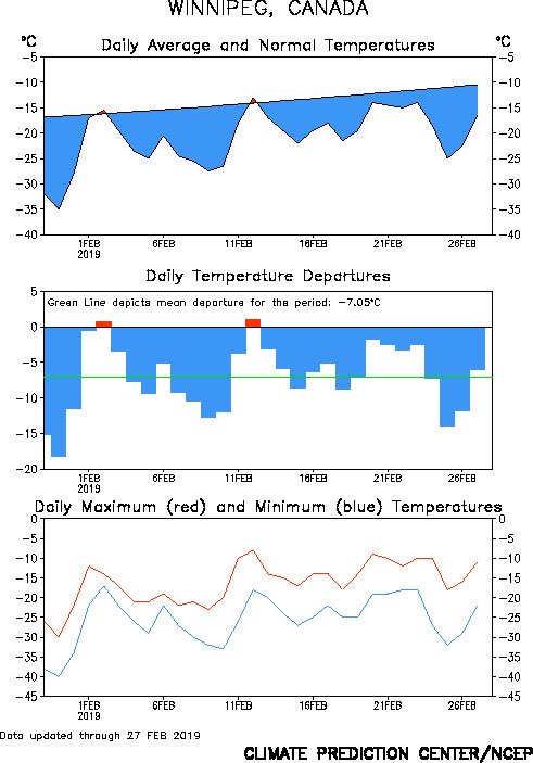
The cold in February was also accompanied by an unusual amount of snow for that time of year. February is normally a month with very little snowfall and that had held true through the 21st century so far. 38.4 cm of snow fell in February 2019 in Winnipeg, 2.7 times the normal of 14.0 cm. It was the snowiest February since 1987 and the wettest since 2009 (February 2009 had a lot of rain).
Manitoba had actually missed the worst of the snow and cold anomalies in February, with areas south of the border and in far western Canada recording one of the snowiest and coldest Februarys ever. In North Dakota, Minot had its second coldest February, Bismarck its fifth coldest February and Fargo its 11th coldest February. In Minneapolis, it was a top 10 snowiest month of all time. Even further west, Seattle, Washington had its snowiest and 3rd coldest February on record. In Alberta and Saskatchewan, cold anomalies greater than 10 degrees were recorded, including in Calgary and Saskatoon where February was about 12.8 degrees and 11.4 degrees colder than normal respectively. For both cities, it was the 4th coldest February on record (according to Weatherlogics). Edmonton International Airport dipped to -41.2°C on February 5, while Saskatoon and Regina dipped to -42.5°C and -42.0°C respectively during the February cold snap.
Thanks in part to the prolonged cold spell, the river trail in Winnipeg set a record for its longest season, being open for more than 70 days.
 |
| Agriculture and Agri-Food Canada map of Prairie temperature anomalies in February |
3 - Driest First Half of the Year On Record
All months from January to June, except February, were drier than normal in Winnipeg. March was most notable with a measly 0.6 mm of precipitation at Winnipeg Airport, the driest March on record since 1872. Only 1.6 cm of snow fell, tied 5th least snowy March. March was dry throughout the Prairies with Regina also recording its driest March on record.
Driest Marches in Winnipeg since 1872

Overall, it was the 9th driest spring on record in Winnipeg and the driest since 1987. Extreme dryness continued into June, a month that is normally the wettest of the year. Only 26.3 mm fell, the 7th driest June since 1873 and the driest since 1974.
The Red River Valley saw rainfall in July and August that was closer to normal, helping to lessen the impacts of the drought. However, parts of the Interlake and Parklands remained dry through the period, causing the greatest impacts to be felt in those regions. Hay and feed for cattle faced a major shortage, causing more than ten municipalities to declare states of disaster to get help from higher governments. The provincial government allowed livestock producers to cut hay and let their animals graze on Crown land to help lessen the impacts. Some producers hauled in water and feed which was expensive. In September, both the provincial and federal governments outlined measures to provide financial assistance to affected producers. The series of three dry years also resulted in an increased prevelance of grasshoppers, particularly in and around the Red River Valley. In Winnipeg, it was a repeat of 2018's shifting soils, causing cracks in foundations and sinking buildings.
2 - Rainiest September on Record
At Winnipeg Airport, 153.1 mm of rain fell in September, the rainiest on record and second wettest since 1872, and 3.2 times the normal.
The rainiest and wettest Septembers since 1872 in Winnipeg

Much of southern Manitoba had a wettest September on record, including Brandon which beat the old record of 140.4 mm in 1921 with a whopping 186.0 mm (more than four times the normal of 44 mm). In Carberry, the 179.4 mm of precipitation was the highest monthly total of all-time since 1962. Several locations in southern Manitoba recorded over 200 mm of precipitation in September, particularly in the southern Red River Valley and southeastern Manitoba. These amounts were completely unprecedented in September and rare for any month of the year, especially when considering the fact that most of the rain fell in only a period of two weeks. September is, on average, only the 5th wettest month of the year with around or under 50 mm, making this one particularly unusual and extreme. The highest monthly amounts were between 230 mm and 270 mm, generally in the Emerson, Morris, Steinbach and Zhoda areas. A Cocorahs site in Zhoda recorded close to 270 mm of precipitation in September, four times the normal. South of the border, Grand Forks, Minot and Williston also recorded their wettest September on record. Overall, it was the wettest September on record for the state of North Dakota.
The heaviest deluge occurred on September 20 and 21, when several rounds of heavy rain and severe thunderstorms pummelled southern Manitoba. The weather pattern was highly unusual for that time of year, with a surge of warm and very humid air from the south that lasted about a week. In the two-day period, Winnipeg received around 50 mm of rain, a month's worth by September standards. However, this was not even close to being the highest amount in southern Manitoba. Brandon recorded 122.2 mm, the greatest two-day precipitation amount of all-time since 1890 (the 48.3 mm on Sep 20 and the 73.9 mm on Sep 21 were both all-time daily records for September). Even that did not match parts of the southern Red River Valley and southeastern Manitoba where locally 130 to 160 mm of rain fell during the two-day period, double to triple the monthly normal.
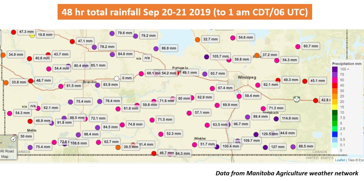 |
| Two-day rainfall amounts Sep 20-21, 2019 across southern Manitoba at Manitoba Agriculture (MAFRI) stations (@robsobs) |
Some might have said the thunderstorm event in the morning of September 20 in Winnipeg was the most significant of the year. A strong mesoscale convective system (MCS) moved through the Red River Valley around the morning rush hour, dumping significant amounts of rain and producing strong winds and frequent lightning. The intensity and scale of the system was unusual for so late in the season (stretching from Berens River to the US border). Wind gusts were generally between 80 and 90 km/h, with a gust of 81 km/h at Winnipeg Airport. The strongest gust was 97 km/h at the Reef Lake MB Fire station near Berens River. Rainfall amounts were the main story with locally 50 to 60 mm within an hour in southwestern parts of Winnipeg. Weather Underground stations in La Salle and Montcalm also recorded severe amounts of 50 mm and 61 mm within an hour respectively. The deluge flooded streets and water poured form the ceiling at the Fairmont Hotel. Nickel to loonie sized hail also fell south of Winnipeg, including in Winkler and Lorette. In Brandon's south end, nickel to hen egg sized hail was reported overnight along with strobe-light lightning. CJOB had a great timelapse of the ominous-looking storms as they moved into downtown Winnipeg, blanketing the city in darkness during mid-morning. Lightning also set off a house fire in Bridgwater.
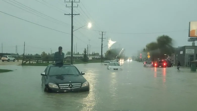 |
| Flooding on Chevrier Blvd in Winnipeg submitted to CBC MB |
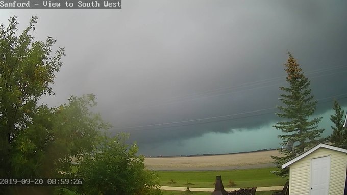 |
| Sanford MB webcam showing ominous skies around 9 am Sep 20 |
Yet more storms moved in late in the day on Sep 20 as well. This time, areas south of Winnipeg were hardest hit with flash flooding being the main issue. Emerson recorded 103.5 mm of rain for the date, an all-time daily rainfall record for September, breaking the old record of 81.3 mm in 1955. 64 mm of this total fell in just an hour. Widespread amounts between 70 and 120 mm occurred, including south of the border. Grand Forks, ND recorded over 100 mm within just a few hours, causing severe overland flooding that flooded farm fields and caused the closure of a portion of I-29.
The greatest impact of the rains in September was on farmers. Rain was needed all year, but then came too late in the season and too heavily. The rain put a damper on harvest operations, with many crops being unharvested or harvested significantly later than normal. The heavy rains also caused rivers to swell at a time when they would normally be falling. Flood warnings were issued south of the border for the Red River. In addition, many MPI claims were submitted for hail and water damage to vehicles, particularly from Winnipeg and Brandon.
One of the most impactful Colorado Lows to ever hit southern Manitoba moved in just before Thanksgiving. It was possibly the worst snowstorm to hit the province since the April 1997 blizzard.
Generally, 40 to 70 cm of snow fell between Brandon and Winnipeg, with the highest amounts from Carberry to Portage southward to the US border, making it one of the worst snowstorms to ever hit southern Manitoba. The area of heaviest snow also stretched as far south as Bismarck and Jamestown in North Dakota. Brandon received 35.2 cm in total, 20.6 cm of which fell on October 11 alone, the 5th highest daily snowfall in October since 1885.
In Winnipeg, 34.0 cm fell at the Charleswood site over 2 days, the largest October snowstorm on record in the city since 1872, beating 27.9 cm Oct 30-31, 1971. It was also the earliest snowstorm to dump over 20 cm of snow (previously 20.3 cm Oct 16, 1878) and the earliest to dump over 30 cm (previously 35.8 cm Nov 7-8, 1986). 21 cm fell on Oct 10 alone, the 2nd snowiest October day since 1872 and the earliest date to record over 20 cm. The snow depth of 30 cm on Oct 12 following the storm obliterated the previous October snow depth record in Winnipeg of 18 cm on Oct 31, 1971. The old record for Oct 12 was just 2 cm in 2006, clearly showing the extremeness of the event. In total, 36.6 cm of snow fell in October, 31 cm above normal and the 2nd snowiest October on record since 1872 and the snowiest in 100 years.

Being during the shoudler season, mixed precipitation occurred as well in the storm. The mixed precipitation zone flirted Winnipeg most of the event with mostly rain southeast of the city and snow to the west. 30-50 mm of rain fell through southeastern Manitoba. In Winnipeg, the snow mixed with ice pellets for several hours in the morning of October 11. This mixing zone resulted in lower amounts in eastern parts of the city compared to the western parts where Charleswood is located. Thundersnow and thunder-ice pellets also occurred east and southeast of the city, including in Steinbach.
Virtually all main highways were closed during the storm, including highways 1, 2, 3, 10 and 14 (among others). I-29 and I-94 were also closed in North Dakota. Highways in Manitoba did not reopen until late in the day on October 12 or early in the morning on October 13.
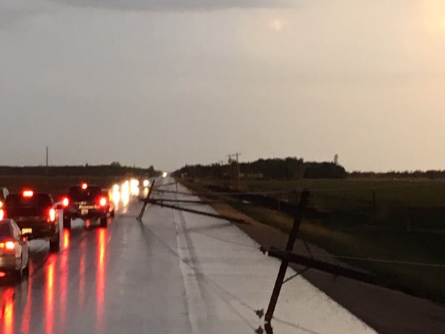
The storm caused a major hydro disaster with a record number of power outages across southern Manitoba. In total, around 150,000 homes and businesses lost power. The storm was estimated to cost Manitoba Hydro more than 110 million dollars. Thousands of hydro poles, and even some hydro towers, knocked over or snapped. The hydro damages were mostly due to a combination of three factors: (1) the extreme wetness/heaviness of the snow, which stuck to everything; (2) the strong wind gusts between 80 and 100 km/h; (3) the foliage still being present on the trees. At one point, the entire city of Portage was without power and residents were asked to not flush their toilets since lift stations were down. One woman was taken to hospital outside Morden due to carbon monoxide poisoning from a propane heater. Power outages continued in the following weeks after the storm due to the number of poles needing to be replaced and due to weakened poles causing new outages. Some 5,000 residents, mostly from First Nations, were also evacuated until power could be restored.
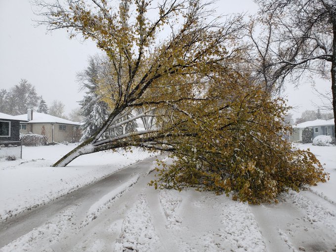
The storm also caused an unprecedented disaster to trees in Winnipeg (dubbed ''tree apocalypse''). Tens of thousands of trees were uprooted, knocked over and shredded by the heavy wet snowfall and strong winds. Fallen trees partially or entirely blocked roadways and sidewalks, making travel difficult. One person was injured by a falling tree. The danger of falling trees prompted the city to close city parks until the clean up could be completed. City parks did not fully reopen until November 19. The full clean up could take a year and the city's tree canopy may take ten years to recover.
States of Emergency were issued by the City of Winnipeg and the Province of Manitoba to facilitate clean up efforts following the storm. Crews from Toronto, Saskatoon, Regina and Calgary arrived to Winnipeg to help clean up trees. Crews from Minnesota, Ontario and Saskatchewan were sent in to help Manitoba Hydro replace broken power poles and towers.
The Winnipeg Floodway was opened on October 9, the first time in the fall on record since 1968. This was a consequence of the storm (with snow melting in only a week) which was preceded by the rainiest September on record. Soils were already saturated and water levels high prior to the October storm. After the storm, the Red River crest on October 24 in Winnipeg was the highest ever recorded in the fall and reached within half a foot of the crest during the 2019 spring flood. Previously, the latest date the floodway was open was on August 4, 2002. It did not close until November 8. High water advisories were issued for many rivers, including the Red, the Assiniboine and the Souris. The incredibly wet fall also put a damper on harvest operations and the potato harvest suffered for the second year in a row.
Exceptionally high river levels continued through November, as high water continued to move in from North Dakota. Such high levels this late in the fall is possibly unprecedented. As floodwaters receded later in November and December, the ice that had built up on the rivers due to a cold November subsided, causing an unusual display along the shores, as seen in the following photo.
As a result of the storm, a long-standing city tradition was cancelled this year. Instead of using a donated tree from a resident, it used an artificial Christmas Tree for City Hall. The tree will be used for a few years. Crews were too busy cleaning up to cut down a tree for City Hall.
1 - Unprecedented October Snowstorm and Fall Flooding
 |
| Carberry by Dallas McDonald |
In Winnipeg, 34.0 cm fell at the Charleswood site over 2 days, the largest October snowstorm on record in the city since 1872, beating 27.9 cm Oct 30-31, 1971. It was also the earliest snowstorm to dump over 20 cm of snow (previously 20.3 cm Oct 16, 1878) and the earliest to dump over 30 cm (previously 35.8 cm Nov 7-8, 1986). 21 cm fell on Oct 10 alone, the 2nd snowiest October day since 1872 and the earliest date to record over 20 cm. The snow depth of 30 cm on Oct 12 following the storm obliterated the previous October snow depth record in Winnipeg of 18 cm on Oct 31, 1971. The old record for Oct 12 was just 2 cm in 2006, clearly showing the extremeness of the event. In total, 36.6 cm of snow fell in October, 31 cm above normal and the 2nd snowiest October on record since 1872 and the snowiest in 100 years.
Snowiest Octobers since 1872 in Winnipeg

Being during the shoudler season, mixed precipitation occurred as well in the storm. The mixed precipitation zone flirted Winnipeg most of the event with mostly rain southeast of the city and snow to the west. 30-50 mm of rain fell through southeastern Manitoba. In Winnipeg, the snow mixed with ice pellets for several hours in the morning of October 11. This mixing zone resulted in lower amounts in eastern parts of the city compared to the western parts where Charleswood is located. Thundersnow and thunder-ice pellets also occurred east and southeast of the city, including in Steinbach.
Virtually all main highways were closed during the storm, including highways 1, 2, 3, 10 and 14 (among others). I-29 and I-94 were also closed in North Dakota. Highways in Manitoba did not reopen until late in the day on October 12 or early in the morning on October 13.
The storm caused a major hydro disaster with a record number of power outages across southern Manitoba. In total, around 150,000 homes and businesses lost power. The storm was estimated to cost Manitoba Hydro more than 110 million dollars. Thousands of hydro poles, and even some hydro towers, knocked over or snapped. The hydro damages were mostly due to a combination of three factors: (1) the extreme wetness/heaviness of the snow, which stuck to everything; (2) the strong wind gusts between 80 and 100 km/h; (3) the foliage still being present on the trees. At one point, the entire city of Portage was without power and residents were asked to not flush their toilets since lift stations were down. One woman was taken to hospital outside Morden due to carbon monoxide poisoning from a propane heater. Power outages continued in the following weeks after the storm due to the number of poles needing to be replaced and due to weakened poles causing new outages. Some 5,000 residents, mostly from First Nations, were also evacuated until power could be restored.
 |
| Fallen tree in Wininpeg posted by Brock Tropea |
States of Emergency were issued by the City of Winnipeg and the Province of Manitoba to facilitate clean up efforts following the storm. Crews from Toronto, Saskatoon, Regina and Calgary arrived to Winnipeg to help clean up trees. Crews from Minnesota, Ontario and Saskatchewan were sent in to help Manitoba Hydro replace broken power poles and towers.
The Winnipeg Floodway was opened on October 9, the first time in the fall on record since 1968. This was a consequence of the storm (with snow melting in only a week) which was preceded by the rainiest September on record. Soils were already saturated and water levels high prior to the October storm. After the storm, the Red River crest on October 24 in Winnipeg was the highest ever recorded in the fall and reached within half a foot of the crest during the 2019 spring flood. Previously, the latest date the floodway was open was on August 4, 2002. It did not close until November 8. High water advisories were issued for many rivers, including the Red, the Assiniboine and the Souris. The incredibly wet fall also put a damper on harvest operations and the potato harvest suffered for the second year in a row.
 |
| Floodway in operation Oct 12 posted by Marc Tellier |
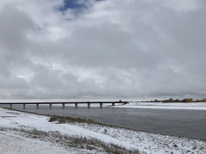
Exceptionally high river levels continued through November, as high water continued to move in from North Dakota. Such high levels this late in the fall is possibly unprecedented. As floodwaters receded later in November and December, the ice that had built up on the rivers due to a cold November subsided, causing an unusual display along the shores, as seen in the following photo.
 |
| Photo of collapsed ice along the shores of the Assiniboine in Winnipeg after floodwater receded |
No comments:
Post a Comment