Tuesday, 31 July 2012

Hot, Possible Severe T-storm Outbreak Again Today

    (photos of Sunday's storms below)
     The cloudier conditions we are experiencing over south-central and southeastern Manitoba will clear out this afternoon. In Winnipeg, we will see clearing within the next 2 hours. There may be a few showers and rumbles of thunder before the skies clear out, however the best risk will be south of the city. Carman, Morden, Morris, Steinbach and Sprague areas could all see this isolated activity over the next few hours.

     Behind the cloud cover, things will heat up into the low to mid thirties. Many ares are expected to rise between 32 and 34°C. Humidity will also be a little higher today, with dewpoints in the high teens and near 20°C in some cases. That will bring humidex values into the high thirties, approaching 40 this afternoon and early evening, if you are not under a thunderstorm of course.

     Speaking of thunderstorms, there is a good risk of another severe thunderstorm outbreak in parts of southern and central Manitoba today. Using MIST (Moisture, Instability, Shear and Trigger), all these ingredients are in play today. A low pressure system will be pushing into the Interlake late afternoon and early evening, with a cold front south of this. This will be the trigger. Moisture will be sufficient with dews in the 17 to 20°C range, and instability will be good in the couple thousand J/kg. Shear is expected to be significant today, and that is a main reason why today may be another severe windstorm day. Due to this high shear, an isolated tornado cannot be ruled out in the early stages of thunderstorm formation, in western Manitoba and the Interlake.

     There will be strong capping however, and this cap is expected to be quite strong along and south of the Trans-Canada. As a result, the best chance for storms and severe weather will be in western Manitoba, into the Interlake and east/southeastern Manitoba.

     Stay tuned to the comment section below, and my thunder forecast tab for updates today. I may issue some moderate severe risk areas in the Interlake later today once I get a better idea at where storms will form.

     Here's some photos of the storms and the damage they caused on Sunday. Keep in mind, today could feature some of the same conditions:
Storm approaching Winnipeg - I took this pic..  my twitter @jjcwpg
Northwest of Winnipeg. Pic by Scott ..  via twitter @steinbachwx
Taken by Jodi Hafenbrak in Winnipeg
Tree blocking traffic on St. Anne's Rd..  pic by Raymond St. Mars..   via twitter @raydawg189

Sunday, 29 July 2012

High Heat and Humidity Today

     It will be another hot one for Manitoba today as temperatures rise into the low thirties, and dewpoints in the high teens and near twenty. This will bring humidex values close to 40 later this afternoon and early evening if you are not under a thunderstorm. It will be one of those days where strenuous activities outdoors should be reduced, and everyone should keep hydrated outdoors. Seeking shade if you have to be outdoors is a great idea.

     Today will also be a watch-the-sky type of day as severe thunderstorms will be possible throughout southern and central Manitoba this afternoon and evening. Severe thunderstorm watches have already been issued by Environment Canada this morning for all of southern Manitoba, excluding only the Virden and Melita areas. Large hail and damaging winds will be possible. A small risk of tornadoes exists in the Interlake due to lake-breeze convergence, and in south-central/southwestern Manitoba. Winnipeg's best risk for storms will be late afternoon and evening.

     Behind these storms, it will be a cooler and drier day tomorrow with highs in the high twenties, and humidity low.

     Things heat up again Tuesday. Highs in the low to mid thirties will be possible, however it will be a drier heat. Humidex values are ''only'' expected to be in the mid to high thirties.

Saturday, 28 July 2012

July Heat Continues

     It will continue to be hot in southern Manitoba for the next several days. Daytime highs will be near 30 for the next week.

     Today, it will be near 30, however it will be a drier heat today. Tomorrow will be a little different. Highs near 32°C are expected for Winnipeg, but humidity will be a little more oppressive. Dewpoints in the high teens and near 20 will give humidex values between 38 and 40. Storms will also be possible today and tomorrow, with the best chance being tomorrow. The best risk will be in the Interlake, western and eastern Manitoba on both days. Large hail and torrential downpours will be the main threats, along with a damaging wind threat tomorrow. Tornadoes don't look likely.

     With a hot end to July, this July will likely end up among the top 5 warmest Julys on record. We may even have a shot at second warmest depending on how warm it is the next few days. Currently, the average mean for July 2012 is 22.0°C. The second warmest July was in 1914, 1916 and 1935 with an average mean of 22.4°C, which is certainly within reach. Stay tuned July 31 and August 1 for the answer!

Sunday, 22 July 2012

Warm, and stormy?

     It will be a hot one today with highs around 31°C in the Winnipeg area. It will be a little humid to start, however humidity levels will gradually decrease in the afternoon hours as a gusty west wind develops. There will be a slight chance of a shower late morning, however the best chance for storms and showers will be to the southeast near Sprague and the Whiteshell. As for this afternoon, it will begin sunny, then clouds will begin to increase late afternoon with another small chance of showers late afternoon and early evening. There will be a small chance of a severe storm near the Ontario border, however the best chance for severe storms will be in northwestern Ontario.
  
     It will be a couple degrees cooler tomorrow behind the trough today. Highs will be in the 27-28°C range, humidity will be low and winds will be light making for a perfect summer's day.

     Things become for turbulent - and uncertain - for mid-week. A strong low is expected to move across the Prairies, which could spark off some strong storms Tuesday in Saskatchewan and Wednesday for Manitoba. However, timing is uncertain so those dates could change. Stay tuned for updates on this event.

     It looks like we'll cool down behind the low, but the cool down will be brief. Indications are that we will return to hot weather by the weekend into next week.

Friday, 20 July 2012

Thunderstorms Rumbled Last Night

Picture taken by BobLedoux
     Thunderstorms finally reached the Winnipeg area last night. They brought heavy rainfall along the north Perimeter, with up to 20 mm of rain reported in the Transcona area. Very little rain fell in other parts of the city however, with only a trace measured in parts of the south end. Unfortunately as a result, the drought conditions in the city.
     Lightning was probably the main show for the city last night, with frequent bolts of lightning across the sky and in the clouds.
     No hail was reported around Winnipeg, however nickel sized hail fell along the US border.

     As for the future, our next chance for some rain or thunderstorms will be tomorrow night and Sunday as another trough moves in. Elevated nocturnal storms will be possible in all of southern and central Manitoba overnight and early Sunday. Flooding rains and damaging winds will be the main threats, however most storms should remain non-severe. Storms will again be possible in the afternoon throughout the region. Some could be severe.

     It will also remain hot over the next couple days. Highs will be in the high twenties and close to 30 today and Saturday. Sunday looks like the hottest day, with highs in the low thirties and humidex values in the high thirties.

Thursday, 19 July 2012

Humidex Advisory


     It will be a very hot and humid day in southern Manitoba today. It may be the hottest day of the year so far. Temperatures are expected to rise into the low to mid thirties, and with the humidity it will feel into the low to mid forties.
     It is one of those days when strenuous activities outdoors should be reduced or taken indoors. If you have to be outside, stay hydrated and try to stay in the shade as much as possible to avoid heat exhaustion.
     All this humidity, along with an approaching trough will offer the opportunity for severe thunderstorms in Manitoba later this afternoon and evening. The best chance for these storms will be in the Interlake and eastern Manitoba. Capping in the atmosphere may prevent storms from forming altogether south of these areas, where the cap is strongest. The main threats today will be large hail, damaging winds and flooding rains. Tornadoes are possible, however conditions for their formation are not as favourable as they were in Saskatchewan yesterday.

Wednesday, 18 July 2012

Extreme Heat Returns

     It will be a mostly cloudy day today in Winnipeg, before things begin to clear mid/late afternoon. There may be a few showers, with perhaps a rumble of thunder, this afternoon and evening. Highs will be generally ''only'' around 27 or 28°C.

     The oven really turns on tomorrow. We will be under a thermal ridge, which will bring us some very hot and humid weather. 850 mb temperatures are expected to rise into the low to mid twenties throughout southern Manitoba. *The reason why we use 850 mb temperatures is that it can be used to estimate the temperature at the surface. In the RRV, you can add about 10 to 13°C to the 850 mb temperature to get the surface temperature on a sunny, light wind summer day.* Therefore, with 850 mb temps in the low to mid twenties, you can estimate highs in the mid to high thirties for southern Manitoba tomorrow.
     A westerly wind in the afternoon will also give a favourable downslope effect to the RRV, which will help maximise the daytime high.
     However, there is a limiting factor to the heat tomorrow; and that will be humidity. Dewpoints are only expected to drop into the high teens in the afternoon. The problem with too much humidity is that humid air does not heat up as well as drier air. Thus, if we stay humid during the afternoon, we will likely only see highs between 33 and 36°C across southern Manitoba. If we manage to get dewpoints lower, into the low to mid teens, then highs between 36 and 39°C would be possible.

     Currently, my best guess is for a high of 34°C in Winnipeg tomorrow, with 35 to 36°C highs in the western and southern RRV (Carman, Portage, Morden, Emerson). What are your guesses? You can write your guesses in the comment section of this post.

Sunday, 15 July 2012

Finally Some Rain

     Winnipeg will finally see some rain this morning with a band of left-over convection from yesterday. General amounts have seemed to be between 5 and 15 mm in southwestern Manitoba overnight with this band, however Winnipeg should see amounts on the lower side, around 5 mm, this morning. This rain is welcomed news to the drought-stricken city, however it may be too little to make much of a difference.
     It doesn't look like we'll clear out much this afternoon behind the rain. There may be a few sunny breaks here and there, but generally it will be a cloudy day. As a result, highs around 23 or 24°C are expected.
     Tonight, things may get interesting. Elevated convection will be possible. With this, a lot of rain, and potentially some lightning, will be possible later this evening and overnight. If we're lucky, we could get 10 to 20 mm of rain, and even higher if we get some thunderstorms going. Stay tuned to the comment section below for updates, as uncertainty lies. As this convection initially forms over southwestern Manitoba and North Dakota, some large hail, damaging winds and excessive rainfall with frequent lightning will be possible for areas south of Brandon, and west of Emerson.

     In the long range, I wanted to give a heads-up on when the heat will start cranking up again.  It looks like things will begin to heat up Thursday, and continue into part of the weekend. Highs in the low to mid thirties and humidex values near 40 will be possible for those few days. It is still far, therefore things could change, however that's how it looks so far.

Thursday, 12 July 2012

Stormy Day Ahead

     Thunderstorms have already rumbled through the Winnipeg area early this morning, and storms are still brewing to our west and southwest as we speak. Severe tstorm warnings are in place due to excessive rainfall. Some areas have already seen over 40 or 50 mm of rain this morning west of Winnipeg.
     Thunderstorms are likely throughout south-central and southeastern Manitoba this afternoon and evening. The main threats are large hail, damaging winds and excessive rainfall. The storms are slow movers today, which explains why some areas are getting such high rainfall amounts. Also, they are quite isolated as a result. For example, Oak Bluff had about 30 mm of rain this morning, while some parts of Winnipeg barely had a drop.
     These showers and storms are expected to continue tonight, mainly over southeastern Manitoba, before moving out into northwestern Ontario by afternoon tomorrow. Hot and sunny weather will return behind the morning rain for the afternoon. Highs in the low thirties and humidex values in the high thirties and approaching 40 are expected for Friday. Saturday will be similarly hot, albeit less humid.

Wednesday, 11 July 2012

Humidex advisory and Severe Thunderstorm Risk


      Humidex values will be pushing 40 today in all of southern Manitoba, reaching as far north as Swan River and the northern Interlake. It is recommend that you reduce strenuous activities outdoors during the peak heat hours of the afternoon in particular. Temperatures this afternoon are expected to reach between 33 and 35°C, and that will be mixed with dewpoints near 20°C.

     In addition, a severe thunderstorm watch has been issued for the western half of the province, all the way up to the Nunavut border. This is due to a trough of low pressure moving east from Saskatchewan. Areas that may see severe storms this afternoon and evening include the Melita, Brandon, McCreary, Dauphin, Swan River, Grand Rapids, Thompson and Tadoule Lake areas. The main threats today are torrential downpours, large hail and damaging winds. Tornadoes are unlikely due to low shear, however in July they can never be completely ruled out.

     It is expected to remain hot and humid Thursday and Friday, and as a result, it will be an uncomfortable next few days. Thunderstorms, some severe, will remain possible both days as well.

Sunday, 8 July 2012

Hot Week Ahead

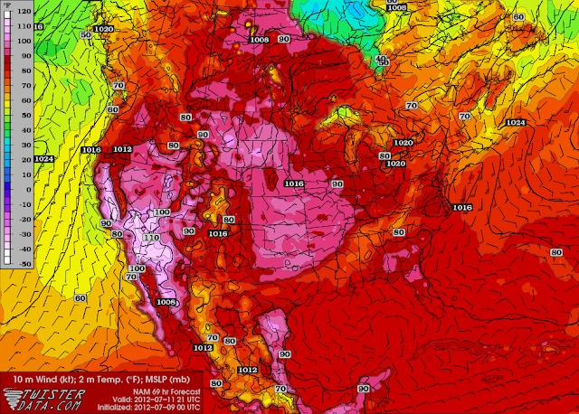
     The heat we have been experiencing for a few weeks now is expected to continue as a large ridge builds over western Canada. Temperatures are generally expected to be near 30°C in southern Manitoba every single day this week, with some days a few degrees warmer and some a couple degrees cooler. The week will start dry with low humidity levels Monday and Tuesday. However, humidity levels will begin to increase Tuesday night, setting the stage for some uncomfortable conditions for southern Manitoba later this week with humidex values likely to approach 40. 
     With the humidity will come an increased risk of thunderstorms. Wednesday, Thursday and Friday all have the possibility for storms, and some may be severe. They are expected to be pop-up type storms with no major large-scale triggers. As a result, they are expected to remain isolated, so not everyone will be seeing storms later this week.

Forecasted high temperatures for Wednesday July 11. Highs in the low to mid thirties expected for southern Manitoba.

     And there is currently no end in sight to the heat in southern Manitoba. All the models seem to point at above normal temperatures (over 26°C) continuing for at least the next 10 days, and perhaps even the next 14 days.

NAEFS Ensemble model points at a 90-100% chance of above normal temperatures in southern Manitoba from July 16 to 23. As a result, there is no end to the heat in the near future.

Friday, 6 July 2012

Next few days

     After about 1 mm of rain in the city this morning, things will begin to clear out this afternoon; later than sooner however. Depending on how early the sun comes out, we could see temperatures between 25 and 28°C by evening.

     Tomorrow will bring another chance for rain. There will be a mix of sun and cloud in general, but there will be a good chance for thunderstorms throughout southern Manitoba in the afternoon and evening. They do not look to be severe at this point, however I would not rule out an isolated severe storm giving large hail, due to moderate instability. Highs are expected to be in the high twenties.

     Sunday will be sunnier, with highs in the high twenties again.

     A large ridge of high pressure is expected to build over western North America this weekend. This could bring some very hot conditions to many areas, and will be the start of summer for BC we could say. This heat will eventually build into southern Manitoba next week. At this point it appears we will get into the heat by mid week with a peak late week. Temperatures in the mid thirties will not be out of the question.

Wednesday, 4 July 2012

Wet Morning

     Some showers with embedded lightning strikes are passing through southeast Manitoba and the RRV so far this morning. Only about 2 to 5 mm of rain is expected with this pre-frontal precipitation.
     Bigger storms are passing along the International Border and up to Minnedosa, and have been for much of the overnight. As a result, excessive amounts of rain has fallen in some areas. 50-100 mm of rain has fallen in the Turtle Mountain, Boissevain and Killarney region so far, and it is still raining in these areas as we speak.
     Some of these storms may reach the Winnipeg area later this morning, however uncertainty in this exists still. It is hard to say if they will weaken, or strengthen. Stay tuned to the comment section below for my updates. If these storms do reach Winnipeg, localized amounts of 10 to 20 mm will be possible.
     Things will begin to clear out later in the afternoon today, allowing temperatures to rise into the high twenties by early evening.

Monday, 2 July 2012

High Humidity Warning & Severe Thunderstorm Watch

     It is recommended that you reduce strenuous activities today in southern Manitoba due to high humidity. Humidex values will be near 40, making it feel very uncomfortable. I personally am issuing a high humidity warning for the RRV for today, as a result.

     All this heat and humidity will clash with a front moving east today. Thunderstorms are likely for most of south-central and southeast Manitoba later this afternoon, and early/mid evening. Keep an eye on the sky! Some of these storms could be quite severe, thanks to extreme instability, moderate shear, high moisture and a trigger. The main threats will be large hail (golf ball to tennis ball sized), flooding rains due to the slow moving nature of the storms, damaging winds, frequent lightning and an isolated tornado.

Sunday, 1 July 2012

12th Consecutive Month Above Normal - June Summary

June summary - Click to enlarge
     June continues a trend that has gone on for 12 months now. The average mean temperature for the month was once again above normal. This was also the first truely above normal June since 2006.

     The month though, was a mixed bag. It started warm and stormy, with multiple thunderstorms in the Winnipeg area. 6 of the first 12 days of the month saw thunderstorms. It became even more unsettled, and much cooler mid month. Businesses who rely on warm and sunny weather suffered for a couple weeks, as skies remained mostly cloudy with daily rain events. In a period of 14 days from the 7th to the 20th, 13 of those days saw rainfall. Despite all the wet weather, we still saw below normal rainfall for the month. That is because we saw several light rain events instead of several heavy rain events.

     Things brightened up late month however. Hot and sunny weather became the name of the game with a full week of sunshine and temperatures in the high twenties and near 30. This turn to summer-like weather creates some worries however. If these conditions continue into July, we could go back to another drought similar to last year's.
June 3 anvil over Winnipeg (looking west)

     As for thunderstorms, two events stood out in the month, namely June 3 and June 9.

     A cold front sliced through southern Manitoba on June 3. Temperatures were hot, and humidity was high, and the cap was insignificant. As a result, strong storms formed along the front and moved east, in the afternoon and evening. One supercell-type storm formed near Elie and moved straight for the extreme south edge of Winnipeg. Due to low shear, tornadoes were not a big threat on this day. However, low shear meant slow-moving storms. 15-25 mm of rain fell in the heaviest hit areas, along with quarter-sized hail.
     
     June 9 was an event to remember. The day started off with an MCS in southern Manitoba. It brought very strong winds in southwestern Manitoba overnight and early morning before weakening as it moved east. It brought very odd cloud formations to the Winnipeg area, as well a good dose of rainfall, and a few lightning strikes.

    In the afternoon and evening, as skies cleared and temperatures rose, there was potential for a significant tornado outbreak thanks to a warm front and high shear. In anticipation of this, many storm chasers, including Reed Timmer, zeroed in on the International Border. Unfortunately (or fortunately), no tornadoes formed that day. Very large hail, incredible lightning and torrential downpours were the main stories.

     A supercell moved right through the city of Winnipeg in the mid evening hours. Very large hail fell in the west end, with golf ball and tennis ball sized hail. Lightning was fantastic as well with almost constant flashes at times.

Morning MCS over Winnipeg. (left: mammatus ahead of storm, taken by me)   (right: by Mary Ellen McMurtry)
Evening supercell over Winnipeg. (left: by me)   (right: by Amanda Smith)
Incredible hail over Winnipeg, by Dennis Kurchaba