
Summer 2012 in Winnipeg followed a similar trend to summer 2011, albeit hotter and a little wetter.
 |
| Aug 7, by Ora Walker |
And was July ever a scorcher! With an average mean temperature of 22.3°C for the month, it was the 5th hottest July on record since 1873. That's only 0.1°C from tying for 2nd hottest. That also makes July 2012 the hottest July in 76 years, and the 6th hottest month ever.
Top 10 hottest Julys since 1873 (mean temperature):
1. 24.2°C 1936
2. 22.4°C 1914, 1916 & 1935
5. 22.3°C 2012
6. 22.2°C 1957 & 1983
8. 22.1°C 1989
9. 21.9°C 1923 & 1974
In addition, the average daytime high for July 2012 was 29.3°C, 3rd hottest on record for July and 6th hottest for any month since 1872. In total, there were 14 days with a high above 30°C, tied for 4th most on record. This is much above the normal of just 4 days above 30°C.
Top 5 Julys with the most 30°C + days:
1. 17 days 1936
2. 16 days 2006
3. 15 days 1914
4. 14 days 1974 & 2012
 Thanks to some warmer days, it was even hotter in Portage, west of Winnipeg, with an average mean temperature for the month of 23.3°C!
 To make things even steamier, high to moderate humidity was often in the cards in July, as well as warm nights. 21 days had a minimum temperature that was warmer than 15°C, while only 1 night had a low in the single digits. As for humidex values, the average daily maximum was 34.5! The monthly max was 42.1 on both the 11th and 19th. Here's some humidex days stats for July 2012, showing that there were indeed more humid days than normal:
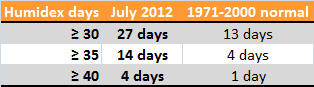
(Unfortunately, I cannot compare these values with other years as I do not have the records for humidex right now. Looks like a project for 2013! (Normals are according to Environment Canada)).
The high heat and humidity through the month prompted the city of Winnipeg to extend spray pad and swimming pool hours all the way until mid evening. In addition, cooling centres were opened in leisure centres and libraries. A temporary water trailer was even added north of downtown on Henry Avenue to refill water bottles. A spike in water use was seen as well, reaching one of the highest rates in the last decade. Some residents were seeing discoloured water from their taps, which was blamed on this increase. It was believed that this caused sediment to stir up in the pipes, causing the discolouration. This sediment however was not dangerous.
Air conditioners were flying off the shelves, with many stores reporting a shortage.
 As for rainfall, July was much drier than normal around Winnipeg for the second consecutive year. With only 23.5 mm of rainfall, it was the 12th driest July on record. Normal rainfall is 79.4 mm. Lawns were parched and some trees were yellowing due to moisture stress and leaf burning. By mid July, it was dry enough for Manitoba Conservation to cancel burning permits and not issue new ones in eastern and northern Manitoba. Wildfires in Alberta and Saskatchewan were already causing smoky conditions throughout much of the Prairies.
However, Winnipeg and parts of the RRV was a bit of a 'drought island'. Most of southern Manitoba, especially in western and northern areas, had actually seen near normal rainfall and in some cases much above normal rainfall in July. This helped produce one of the best crops in years for many farmers. The worst of the thunderstorms were quite simply consistently bypassing this 'drought island'. Even around Winnipeg though, there was some variety of amounts. Some highly localized and quasi-stationary storms over the southwest portion of the city on July 12 dumped some impressive amounts. That brought monthly totals up to around 40 mm for Whyte Ridge, higher than 50 mm for Oak Bluff and 60.1 mm for Starbuck. Here's a map of rainfall totals in July 2012 across southern Manitoba.
In the contiguous United States, July 2012 was the hottest month in history, beating July 1936. Nationally in Canada, it was the same story; the hottest month on record.
As introduced at the top of this post, the heat cranked up again in late August. August 22 to 24 was an official heat wave with highs of 32°C and 33°C on each of those 3 days in Winnipeg. It was even hotter on August 29, with highs in the mid to high thirties across southern Manitoba. This was also accompanied by unseasonably high humidity for that time of year as humidex values reached or exceeded 40. Here are some records that were broken August 29:

Winnipeg reached 35.4°C, just shy of the old record of 36.1°C in 1972. Also, thanks to a breezy south wind, it was still 30°C at 10 PM. Of note, it also hit 40°C in Minot and 44°C in Chamberlain, South Dakota.
As for the entire summer, summer 2012 (June-July-August) ended with an average mean of 19.8°C, 1.4°C above normal and tied for 10th warmest summer. In total, 21 days had highs above 30°C, much above the normal of 11 days for the 3 month-period. Daytime highs averaged 26.9°C, 7th hottest on record.
As well, the period from January to August was at its most warmer than normal ever; 0.25°C more above normal than the previous record in 1987.
 |
| Harvest began in August, by Bob Enns |
Nationally, it was the hottest summer on record in Canada, and 1.9°C above normal. July to September was the warmest three-month period ever.
________________________________________________________________________________
This post contains some information, photos or videos from the following sources:
Robsobs
Rob's Blog
Environment Canada Weather Office and Top 10 Weather Events of 2012
Manitoba Agriculture Weather
A Weather Moment Blog
CBC Manitoba
CTV Winnipeg
Google Maps
The Weather Network
orawalker.com
No comments:
Post a Comment