


Back here in Manitoba, there is the potential for thunderstorms today. Some may be severe for south-central and southeastern parts of southern Manitoba.
Unsettled conditions continue for Sunday and Monday with a chance for some showers and storms. However, for tomorrow there will still be abundant sunshine with highs reaching mid to high 20's again. A little cooler on Monday in the low 20's.
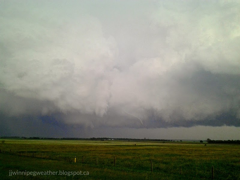
Of note, it is hard to see the tornado in some of these pictures. In the 4th picture, there is a tornado there in the middle of the picture which is hard to see. In the 3rd picture there are actually 2 funnels... the one on the left again is very hard to see.
ReplyDeleteI'm thinking now that severe weather is looking less and less likely especially for areas around and west of Winnipeg including Winnipeg. A 16Z balloon was launched at the U of M which revealed a very stable atmosphere at the moment. If severe weather does occur, it will likely be east of Winnipeg where best dynamcis appear to be.
ReplyDeleteYes, I was there for the launch ;)
DeleteAnon based on conventional ways of checking weather I see that there is Cirrus clouds outside attm here in Winnipeg, and guess what they generally appear white or light gray in color. It forms when water vapor undergoes deposition at altitudes above 5,000 m (16,500 ft) in temperate regions and above 6,100 m (20,000 ft) in tropical regions. It also forms from the outflow of tropical cyclones or the anvils of cumulonimbus cloud. Since cirrus clouds arrive in advance of the frontal system or tropical cyclone, it indicates that weather conditions may soon deteriorate. While it indicates the arrival of precipitation (rain), cirrus clouds per se produce only fall streaks (falling ice crystals that evaporate before landing on the ground).
ReplyDeleteFrom Wiki above
DeleteI see a number of towering cumulus going up west and southwest of the city. Let the action begin perhaps.
ReplyDeleteWell, looks like the action will be and is in western MB as per usual. Go figure the area that had a lesser threat for storms.
ReplyDeleteWell, in a way thats better then then things forming over the areas that where forecasted to get severe thunderstorms ( there are in fact some severe thunderstorm watches and WARNINGS in western manitoba). That way theres a chance them creeping into the RRV later; if they where east of the city then they simply keep moving eastward. Nonetheless, I would still say some strong or severe will form around here ( that is if the perimeter shields don't work today ) and east of here.
DeleteAnon... Just because the storms are developing there doesn't mean that they won't make it over here in Winnipeg. I have faith being religous and sometimes you just have to have hope in things that seem bleek. Come on where's your positivity?
DeleteAgreed. That might be our chance for storms given that storms which are forming west are moving east, so we'll see.
ReplyDeleteThose must be deafening cannons over St Vital Park. Bright lites with them too Anyone know if thats just a midday solstice salute or can we expect encores? lol
DeleteGreat pics Jj. There are some summers youll see that east of I 29 every week in July.Especially from just south of Fargo
ReplyDeletePretty nice rapidly developing severely warned small little cell just southeast of the city.. Small but ferrous! Got a feeling that thats the beginning of severe cels east of here and that Winnipeg might be in a little "hole" today in the end, with severe cells all around us.
ReplyDeleteThat said i might go chasing. The question is just where to go; theirs storms east, north and west of here lol!!
DeleteI plan on going chasing north of the city that would be the best bet, unless something develops south of the current storms that are out west. We'll see i guess...
DeleteTornado warned cell near Lorette at the moment. Looks like a tornado may have touched down in the area,
ReplyDeleteThat tornado warned cell has now been dropped.
ReplyDeleteAnybody think that Winnipeg could get into some of this action??
ReplyDeleteWow, that's a nasty cell that formed just southeast of the city this afternoon... It's actually a good thing that one missed us. However, there was a crashing boom of thunder earlier in St Vital.
ReplyDeleteHowever, there is a good chance we could get into the action this evening as the storms in southwestern Manitoba move in. Hopefully nothing strange occurs and we miss out...
Yeah, any further reports as to the tornado?
DeleteHaven't seen anything about tornadoes, but have seen a photo of a funnel cloud on twitter. Haven't had the chance to see the storm due to work.
DeleteSevere thunderstorm watch now includes Winnipeg.
ReplyDeleteYes, can't rule out that line to our west to expand south. There's an obvious outflow boundary to its south visible on radar imagery which will have to watch for nearby development. Also some hints of storms around Brandon for later.
DeleteI see storms are developing between Brandon Portage along highways 2 and the trans canada moving east. Will have to monitor that closely as well. Pretty nasty looking cells on the south end of lake Manitoba just now coming offshore.
ReplyDeleteI am heading out with Matt to check out the storms to our west. I would not be surprised to see things expand south soon or the storm may begin to turn to the right a bit. Certainly not over for Winnipeg. Also interesting, there appears to be a popup right over the city at the moment with a large towering cumulus forming.
DeleteThings are starting to expand south. Winnipeg could get something soon if the trend continues.
ReplyDelete