
Even warmer temperatures were felt on Monday to the southwest of the city where snow is almost non-existent, as seen in the visible satellite below. Highs were above zero in many areas, including +4°C in Carman, +3°C in Pilot Mound and 0°C in Brandon.
 |
| Dark areas to the southwest of WPG indicate bare ground. White areas in parts of ND and southeast SK are just cloud. Ground is pretty bare there as well. |
What little snow is actually on the ground this week will be slowly melting thanks to mild temperatures which are making it look and feel a lot more like March. At this time of year, we are normally in the dead of winter with our deepest snow depth of the winter. This winter has other plans...
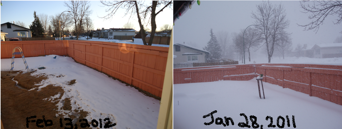
 |
| What little winter we had is slowly melting away... =) |
This spectacular weather will continue through the rest of the week. Overnight lows will be a little chilly in the minus teens, although daytime highs will be terrific near the freezing mark, and even a little above on some days and in some areas, mainly in areas where snow is almost non-existent. The only downside will be that cloud will begin to move in tomorrow. It wont be perfectly sunny tomorrow or Wednesday; it will be more of a mix of sun and cloud. We may even see a little snow Thursday and Thursday night, though it will be very light with likely just a dusting.
Temperatures look to cool down by the weekend, although it will likely just be closer to normal. Any cool down will be brief with what appears to be another warm up to start next week.
In case you were wondering how this winter is doing in the record books so far, here's a glimpse.
So far (up to Feb 12), this winter's average mean temperature is -10.2°C. If we manage to maintain that average mean, this would be the 5th warmest winter on record since records began in 1873. Of course, it is unlikely we'd maintain that average, athough it is very likely this winter will end up being somewhere between the 4th and 7th warmest on record.
Top 10 warmest winters since 1873
Mean temperature Year
1. -7.2°C 1877/1878
2. -8.2°C 1997/1998
3. -9.5°C 1986/1987
4. -10.1°C 1930/1931
5. -10.8°C 1991/1992 and 2005/2006
7. -10.9°C 1982/1983
8. -11.6°C 1999/2000
9. -11.7°C 1939/1940 and 2001/2002
Interesting how 5 of the top 10 warmest winters were in the past 20 years... This year would make that 6.
In addition, only 48.0 cm of snow has fallen so far this winter, which is well below the normal 75 cm we would have normally seen by now. I am still gathering the stats for least snowy winters, and will likely have those stats by the end of the month.
The AO has recently changed to positive, and is expected to remain positive for now.
ReplyDeleteLooks like Europe can finally get a break on the brutal cold now, now that the AO has switched. The negative AO we've seen recently allowed for a lot of that arctic air to spill southwards into that continent.
Any cool down we will see here in the next while will likely be quite short-lived, similar to what we've been seeing so far this winter.
Temperature just reached 0.0°C here at my place in south end. Generally between -3 and 0 in the city, and even warmer out west. +1°C in Portage, 3°C in Pilot Mound and 5°C in Morden.
ReplyDeleteLooks like the cloud will hold off a bit, so luckily we have squeazed in another extra day of pure sunshine today :) It wont last, it will begin to cloud over tonight, and it will be a much cloudier day tomorrow.
Crazy February day today, here's some highs:
ReplyDeletePortage 2°C
Melita 3°C
Emerson 4°C
Carman 6°C
Morden 7°C !
Most of Winnipeg reached about 1°C today, with the airport really being the odd one out, only reaching -1 or -2°C
The snow today ended up being much more extensive than forecast. Not a heavy snow, but it is coming down pretty good in bursts. It should begin to taper off late this afternoon or very early in the evening.
ReplyDeleteAbout 4 cm of wet snow yesterday in the city, much more than any model or meteorologist/forecaster was predicting. An unexpected snowfall. It will have many opportunities to melt in the next week with warm weather continuing. Temperatures above zero are possible this weekend in southern Manitoba, as opposed to the earlier forecast of colder weather. Friday and Saturday morning will be the cooler times, though only a few degrees cooler than the past few days. Awesome weather ahead :)
ReplyDeleteGet ready for an awesome weekend! Thankfully it's a long-weekend so most of us can enjoy the full length of this warm spell before things cool off slightly by mid next week.
ReplyDeleteSaturday will approach the freezing mark after a cool start to the morning in the mid minus teens.
Sunday and Monday will take the cake. Moderate south winds Sunday will usher in nice 950 mb temperatures near or just above zero. With sunshine, that would translate to highs between 0 and 7°C in general across southern Manitoba. Probably closer to 2 to 4°C in WPG.
Monday will be similar, although it will likely be cloudier. There lies uncertainty at this point about Monday and Tuesday as a clipper system develops in Alberta. Some models bring as much as 5 cm of snow, while others show virtually nothing. We'll have to wait and see at this point. Highs Monday will likely be once again above zero.
Awesome afternoon behind that cloud cover this morning. One of those days today where it's much warmer inside the city than at airport. For instance, it's -6°C at the airport as of 3 PM, while it's -2°C in Charlswood, just a few kilometres away.. The snow covered field at the airport reflects much of the sun's heat.
ReplyDeleteNice to see the sun strengthening again :) Snow is melting in the sun despite these below zero temperatures, and you can sure feel the sun's heat.
Up to 5°C in Carman and 4°C in Morden with many more above zero readings across southern Manitoba today. A little lower in WPG with highs so far around 0 or -1°C.
ReplyDeleteTomorrow will likely be just as warm, if not even a little warmer. Tomorrow might not warm to its full potential thanks to increasing cloud in the afternoon. So the later the cloud moves in, the warmer it will get. Snow-covered areas of course will also stay a couple degrees cooler than bare-ground. My prediction for tomorrow is as follows:
Winnipeg 2 to 4°C
western RRV 3 to 7°C
Brandon 1 to 3°C
Things get a little more interesting Monday and Tuesday with a nearby colorado low, as well as a clipper behind that low. Current indications show most of the snowfall falling south and east of Winnipeg, which would amount to just 1 or 2 cm in the city, while closer to 5-10 cm near the Ontario border.
A secondary system following close behind would bring an additional 2-4 cm Tuesday to much of southern Manitoba.
That's the current forecast, although take it with a grain of salt. Things may change quite a bit as the storm draws closer. Models have been handling low pressure systems poorly lately in our area.
Stay tuned for updates :)